IMAGES TAKEN NEAR TO
Priory Road, TORQUAY, TQ1 4NY
Introduction
This page details the photographs taken nearby to Priory Road, TQ1 4NY by members of the Geograph project.
The Geograph project started in 2005 with the aim of publishing, organising and preserving representative images for every square kilometre of Great Britain, Ireland and the Isle of Man.

There are currently over 7.5m images from over14,400 individuals and you can help contribute to the project by visiting https://www.geograph.org.uk
Image Map
Images are licensed for reuse under creativecommons.org/licenses/by-sa/2.0
Notes
- Clicking on the map will re-center to the selected point.
- The higher the marker number, the further away the image location is from the centre of the postcode.
Image Listing (770 Images Found)
Images are licensed for reuse under creativecommons.org/licenses/by-sa/2.0
Image
Details
Distance
1
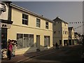
Empty premises, St Marychurch
Next to, and formerly the china and glass part of, Drowers ironmongers (extreme left, with a display of brooms). This is a dead end for vehicles; if you turn left into Rowley Road, you reach in 40 metres a row of bollards across the road. Fore Street continues as a pedestrian precinct.
Image: © Derek Harper
Taken: 4 Sep 2014
0.01 miles
2
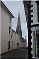
Priory Road, St Marychurch
A reverse view of Image The lighting has turned out very differently from the same view in Image, which gives details of the buildings.
Image: © Derek Harper
Taken: 7 Jan 2022
0.01 miles
3
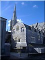
Church with spire and church with tower in St Marychurch
Image: © Sarah Charlesworth
Taken: 3 Jul 2010
0.01 miles
4
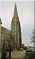
St. Marychurch, spire
At Our Lady Help of Christians & St. Denis RC Church.
Image: © Mike Faherty
Taken: 5 Nov 2018
0.02 miles
6
Church and former convent, St Marychurch
Church, former convent and orphanage, of Our Lady, Help of Christians and St Denis. Now occupied by Margaret Clitheroe House, a care home for the elderly.
Image: © Roger Cornfoot
Taken: 8 Mar 2007
0.02 miles
7
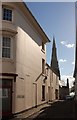
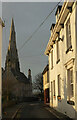
Priory Road, St Marychurch
A wider angle version of the scene in Image at a different time of day, with the corner of a building on Fore Street in the foreground. Again, the Presbytery http://www.britishlistedbuildings.co.uk/en-390763-presbytery-to-church-of-our-lady-help-of#.Vgj6en3-tuR and Church of Our Lady Help of Christians and St Denis http://www.historicengland.org.uk/listing/the-list/list-entry/1206830 can be seen along the narrow street.
Image: © Derek Harper
Taken: 21 Sep 2015
0.02 miles
8
Priory Road, St Marychurch
Approaching the T junction with Fore Street.
Image: © Derek Harper
Taken: 7 Jan 2022
0.02 miles
9
Presbytery and Church of Our Lady Help of Christians and St Denis, St Marychurch
Looking down Priory Road from the junction with Fore Street. The Presbytery http://www.britishlistedbuildings.co.uk/en-390763-presbytery-to-church-of-our-lady-help-of and the church https://historicengland.org.uk/listing/the-list/list-entry/1206830?section=official-listing both date from 1865, and were designed by Joseph Hansom. "A remarkably intact C19 Roman Catholic church".
Image: © Derek Harper
Taken: 21 Jul 2010
0.02 miles
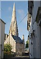
10

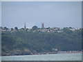
Churches, St Marychurch
In this view from the junction of Priory Road and St Margaret's Road, the spire of Our Lady, Help of Christians and St Denis Image dominates the tower of St Mary's Church Image
Image: © Derek Harper
Taken: 7 Nov 2012
0.02 miles