IMAGES TAKEN NEAR TO
Murley Crescent, TEIGNMOUTH, TQ14 9SH
Introduction
This page details the photographs taken nearby to Murley Crescent, TQ14 9SH by members of the Geograph project.
The Geograph project started in 2005 with the aim of publishing, organising and preserving representative images for every square kilometre of Great Britain, Ireland and the Isle of Man.

There are currently over 7.5m images from over14,400 individuals and you can help contribute to the project by visiting https://www.geograph.org.uk
Image Map
Images are licensed for reuse under creativecommons.org/licenses/by-sa/2.0
Notes
- Clicking on the map will re-center to the selected point.
- The higher the marker number, the further away the image location is from the centre of the postcode.
Image Listing (53 Images Found)
Images are licensed for reuse under creativecommons.org/licenses/by-sa/2.0
Image
Details
Distance
1

The top of Murley Crescent and its view, Bishopsteignton
Across the river we can see some 2 km of foreshore in gridsquares Image Image and Image Half left, the Arch Brook joins the Teign; to the right of the right-hand pole is the Coombe Cellars pub. At far right are the woods around Netherton House. The view is from the junction with aptly-named Teignview Road; cropped to exclude distracting features of the car.
Views back are Image and Image, both by Derek Harper.
Image: © Robin Stott
Taken: 20 Jul 2019
0.05 miles
2
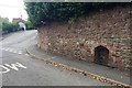
Hole in the wall, Forder Lane, and Murley Crescent, Bishopsteignton
A spring? A stream? A surface water drain? There is what looks like a rail at footpath level – perhaps to rest a bucket on? Or to guard feet from slipping?
Image: © Robin Stott
Taken: 20 Jul 2019
0.08 miles
3
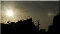
Sundog, Bishopsteignton
At, I assume, its correct 22° angle to the sun on the left, this is seen from Teign View Road. Has it also captivated the bird on the wire? Several of the images at https://www.geograph.org.uk/search.php?i=153718676 carry an explanation of the phenomenon.
Image: © Derek Harper
Taken: 22 Mar 2022
0.08 miles
4
North end of Footpath No.19, Bishopsteignton
The view is the reverse of Image Ahead is Forder Lane. On the right is the substation 'Huntley 34-0391' operated by Western Power Distribution. Huntley, more recently Huntly, is the large property on the other side of the wall.
Image: © Robin Stott
Taken: 20 Jul 2019
0.09 miles
5
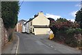
West Town Cottages, Forder Lane, Bishopsteignton
Nos 1 and 2 (furthest) are listed grade II https://historicengland.org.uk/listing/the-list/list-entry/1147821
Image: © Robin Stott
Taken: 20 Jul 2019
0.09 miles
6
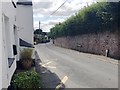
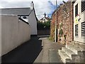
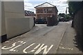
Forder Lane at West Town Cottages, Bishopsteignton
The four cottages are on the left. The turning to Littlefield is just visible past the bend. The entry to Footpath No.19 is behind the camera.
Image: © Robin Stott
Taken: 20 Jul 2019
0.09 miles
7
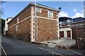
Sandstone building by Huntly, Forder Lane, Bishopsteignton
Huntly, the cream-painted building partly visible on the left, was the largest of several large houses in the village, according to the Bishopsteignton village website https://contact94599.wixsite.com/mysite/history (the 1889 and 1905 OS maps call it Huntley). "In 1878 it was established as a hydro hotel, offering Turkish baths and massages". At the other end of the handsome building pictured a high wide archway has been filled in, suggesting that it was a coach house and stables, or it served the gardeners Image Now it appears at least partly converted to residential accommodation.
Image: © Robin Stott
Taken: 20 Jul 2019
0.09 miles
8
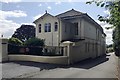
Huntly: the Forder Lane frontage, Bishopsteignton
The Bishopsteignton village website https://contact94599.wixsite.com/mysite/history recounts that Huntly is the largest of several large houses in the village. "In 1878 it was established as a hydro hotel, offering Turkish baths and massages" (and named Huntley on the 1889 and 1905 OS maps). "In 1950 Huntly was purchased by the Officer's Association and is now run as a home for retired officers of the armed forces." There are indications of a change of status since then because properties are publicly advertised for sale.
Image: © Robin Stott
Taken: 20 Jul 2019
0.10 miles
9
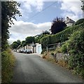
Near the top of Smith Hill, Bishopsteignton
Teignview Road joins from the right and continues to Clanage Cross and Colway Cross. Garages at street level serve houses perched several metres up the hill, where they enjoy magnificent views: Image gives an idea.
Image: © Robin Stott
Taken: 20 Jul 2019
0.10 miles
10
Sandstone building southwest of Huntly, Forder Lane, Bishopsteignton
Huntly, the cream-painted building partly visible on the left, was the largest of several large houses in the village, according to the Bishopsteignton village website https://contact94599.wixsite.com/mysite/history . "In 1878 it was established as a hydro hotel, offering Turkish baths and massages" (and named Huntley on the 1889 and 1905 OS maps). At this end of the handsome building pictured in Image a high wide archway has been filled in above the ground floor window, suggesting that it was a coach house and stables, or it served the gardeners. Now it appears at least partly converted to residential accommodation.
Image: © Robin Stott
Taken: 20 Jul 2019
0.10 miles