IMAGES TAKEN NEAR TO
Howard Close, TEIGNMOUTH, TQ14 9NW
Introduction
This page details the photographs taken nearby to Howard Close, TQ14 9NW by members of the Geograph project.
The Geograph project started in 2005 with the aim of publishing, organising and preserving representative images for every square kilometre of Great Britain, Ireland and the Isle of Man.

There are currently over 7.5m images from over14,400 individuals and you can help contribute to the project by visiting https://www.geograph.org.uk
Image Map (Loading...)


Getting Data...Please wait
Leaflet Map data © OpenStreetMap
Images are licensed for reuse under creativecommons.org/licenses/by-sa/2.0
Notes
- Clicking on the map will re-center to the selected point.
- The higher the marker number, the further away the image location is from the centre of the postcode.
Image Listing (45 Images Found)
Images are licensed for reuse under creativecommons.org/licenses/by-sa/2.0
Image
Details
Distance
1
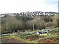
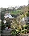
Coombe Valley allotments, Teignmouth
The plots slope down towards the Bitton Brook – upstream it was called the Buddle Brook. Across the valley is the Moor View Drive estate in Image
Image: © Robin Stott
Taken: 11 Dec 2012
0.05 miles
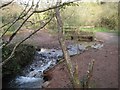
2
A full Buddle Brook, Coombe Valley Local Nature Park, Teignmouth
There had been heavy rain in previous days. The brook in spate has coursed through this old ford and stripped the ground of vegetation and soil. Note the coppiced hazel, a feature of the park.
Image: © Robin Stott
Taken: 11 Dec 2012
0.07 miles
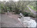
3
Ford and footbridge on Buddle Brook, Coombe Valley Local Nature Park, Teignmouth
There had been heavy rain in previous days. The brook in spate has coursed through this old ford and stripped the ground of vegetation and soil. Branches of coppiced hazel, a feature of the park, get into the picture.
Image: © Robin Stott
Taken: 11 Dec 2012
0.07 miles
4
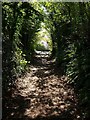
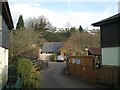
Track beside Coombe Valley Nature Park
The track, enclosed by trees, approaches Paddons Lane.
Image: © Derek Harper
Taken: 22 Aug 2008
0.09 miles
5
West on Paddons Lane, Teignmouth
The former Higher Coombe Farm is on the left. The Moor View Drive estate climbs the hill in Image
Image: © Robin Stott
Taken: 11 Dec 2012
0.11 miles
6
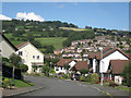
Valley Close, off Moor View Drive, Teignmouth
Across the Coombe valley are tiers of closes off Raleigh Road, climbing the valley-side. Just on the edge of them is Frobisher Wood, possibly a Local Nature Reserve. This hillside to the north of Teignmouth goes steeply up and up and up, culminating in the ridge of Holcombe Down.
Image: © Robin Stott
Taken: 19 Aug 2012
0.14 miles
7
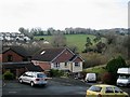
West across the end of Gilbert Avenue, Teignmouth
Across the valley of the Buddle Brook the Moor View Drive estate stops abruptly against farmland, but for how long?
Image: © Robin Stott
Taken: 11 Dec 2012
0.15 miles
8
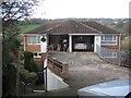
Semi-detached house on a steep slope, Bligh Close, Teignmouth
Apparently, a bridge allows vehicle access to first floor garages. How the rest of the house is arranged is not known but it could be that reception rooms and kitchen are on the first floor with bedrooms and bathroom downstairs. At lower left the footpath through the northwest side of the estate drops steeply down to Gilbert Avenue.
Image: © Robin Stott
Taken: 11 Dec 2012
0.15 miles
9
Close off Coombe Lane, Teignmouth
The road into the close crosses the Bitton Brook. The estates around Coombe Drive spread over the hillside.
Image: © Robin Stott
Taken: 11 Dec 2012
0.16 miles
10
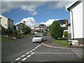
Up Moor View Drive (1), Teignmouth
Seen from the corner of Galloway Drive.
Image: © Robin Stott
Taken: 19 Aug 2012
0.16 miles