IMAGES TAKEN NEAR TO
Exeter Road, TEIGNMOUTH, TQ14 9HZ
Introduction
This page details the photographs taken nearby to Exeter Road, TQ14 9HZ by members of the Geograph project.
The Geograph project started in 2005 with the aim of publishing, organising and preserving representative images for every square kilometre of Great Britain, Ireland and the Isle of Man.

There are currently over 7.5m images from over14,400 individuals and you can help contribute to the project by visiting https://www.geograph.org.uk
Image Map
Images are licensed for reuse under creativecommons.org/licenses/by-sa/2.0
Notes
- Clicking on the map will re-center to the selected point.
- The higher the marker number, the further away the image location is from the centre of the postcode.
Image Listing (419 Images Found)
Images are licensed for reuse under creativecommons.org/licenses/by-sa/2.0
Image
Details
Distance
1
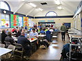
Having a well earned rest after walking 101 miles
Teignmouth Community School was the finishing point of the Camel-Teign Ivor's Dream 100.
Image: © Ian S
Taken: 27 May 2013
0.05 miles
2
Teignmouth College Performing Arts Centre
Image: © Des Blenkinsopp
Taken: 18 Jun 2011
0.06 miles
3
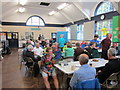
Having a well earned rest after walking 101 miles
Teignmouth Community School was the finishing point of the Camel-Teign Ivor's Dream 100.
Image: © Ian S
Taken: 27 May 2013
0.06 miles
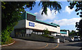
4
Former Knoll Hotel, Winterbourne Road
An undated page on the Rightmove website says "The site comprises the former Knoll Hotel and detailed planning consent has been granted for the demolition of the existing building and the construction of a four storey building comprising 21 apartments with no social housing requirement."
Image: © Robin Stott
Taken: 6 May 2012
0.06 miles
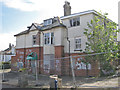
5
Teignmouth Community School
The entrance drive from Exeter Road. The school, previously Teignmouth Community College, was renamed Teignmouth Community School in 2011.
Image: © Derek Harper
Taken: 30 May 2021
0.06 miles
6
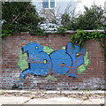
BOF graffito, Winterbourne Road
When my children were at secondary school through the nineties and noughties 'bof' (short for boffin, I believe) was a term of contempt for anyone who showed the least academic ability. This view is a puzzle; there may have been some demolition since the current satellite imagery.
Image: © Robin Stott
Taken: 6 May 2012
0.06 miles
7
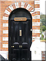
Doorway, Higher Brimley Terrace
Image: © Robin Stott
Taken: 6 May 2012
0.07 miles
8
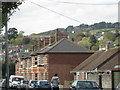
South end of Higher Brimley Terrace
The middle of the terrace is seen in Image and the villa at the north end is seen in Image Beyond this engaging polychrome brick terrace Teignmouth's estates sprawl up the hillsides; Holcombe Down, upper right; new buildings at Trinity School beyond the terrace's chimneys.
Image: © Robin Stott
Taken: 6 May 2012
0.07 miles
9
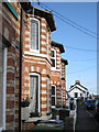
Bay windows, Higher Brimley Terrace
Brimley House beyond. Intervening 20th-century properties are set back from the road Image More of this polychrome terrace is seen in Image; the doorway of the end house is in Image
Image: © Robin Stott
Taken: 6 May 2012
0.07 miles
10
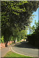
Exeter Street, Teignmouth
The former main road from Haldon arriving in the town centre.
Image: © Derek Harper
Taken: 30 May 2021
0.07 miles