IMAGES TAKEN NEAR TO
Rocky Lane, TEIGNMOUTH, TQ14 9HF
Introduction
This page details the photographs taken nearby to Rocky Lane, TQ14 9HF by members of the Geograph project.
The Geograph project started in 2005 with the aim of publishing, organising and preserving representative images for every square kilometre of Great Britain, Ireland and the Isle of Man.

There are currently over 7.5m images from over14,400 individuals and you can help contribute to the project by visiting https://www.geograph.org.uk
Image Map
Images are licensed for reuse under creativecommons.org/licenses/by-sa/2.0
Notes
- Clicking on the map will re-center to the selected point.
- The higher the marker number, the further away the image location is from the centre of the postcode.
Image Listing (82 Images Found)
Images are licensed for reuse under creativecommons.org/licenses/by-sa/2.0
Image
Details
Distance
3

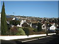
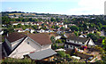
Looking north across Hawkins Drive, Teignmouth
Seen from the Exeter Road the roofs of Hawkins Drive are below the camera. New Road crosses the picture below centre with the cemetery beyond it in Image Beyond that, new estates have climbed relentlessly up these steep hillsides. The highest line of houses is Maudlin Drive with the fields of Holcombe Down on the ridge above in Image It seems to me important that these fields are not built on; they make the town feel contained. To the east, the houses reach the skyline and could go on for ever.
Image: © Robin Stott
Taken: 15 Mar 2016
0.06 miles
4
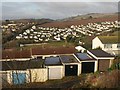
Garages, Higher Coombe Drive
There is an overlap on the right with Image The houses behind the garages face Deer Park Avenue. In the bottom of the Bitton Brook valley is the football ground beside Coombe Lane. The housing on Moorview Drive beyond is in Image and Image
Image: © Derek Harper
Taken: 13 Feb 2009
0.06 miles
5
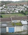
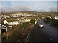
Below Higher Coombe Drive
Beyond the rooftops of Deer Park Avenue is a match in progress on Teignmouth Football Club's ground off Coombe Park Road http://www.geograph.org.uk/photo/1317980 Across the Coombe valley is the Moor View Drive estate creeping up the hillside towards Headway Cross Image In the distance are the outskirts of Bishopsteignton and a glimpse of blue hills. For a wider view see http://www.geograph.org.uk/photo/1165497
Image: © Robin Stott
Taken: 9 Dec 2012
0.07 miles
6
Looking north-northeast across the top of Hawkins Drive
Image: © Robin Stott
Taken: 10 Dec 2012
0.09 miles
7
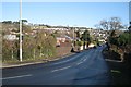
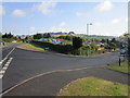
West end of New Road
New Road is a busy link between the Exeter Road and the Dawlish Road and the residential estates along the way. It runs very roughly along the contours through Teignmouth's northern hillside suburbs.
Image: © Robin Stott
Taken: 10 Dec 2012
0.09 miles
8
Looking east-northeast from the top of Hawkins Drive
Image: © Robin Stott
Taken: 10 Dec 2012
0.10 miles
9
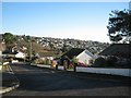
Higher Coombe Drive, Teignmouth
The southern end of the road, dropping from the junction with Exeter Road, gives a good view across the Bitton Brook valley to housing along Moorview Drive, and up to Little Haldon.
Image: © Derek Harper
Taken: 13 Feb 2009
0.10 miles
10
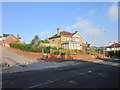
View of Part of Teignmouth
Just a general view of this residential part of town from an overlook beside the Exeter Road.
Image: © Des Blenkinsopp
Taken: 18 Jun 2011
0.11 miles