IMAGES TAKEN NEAR TO
Maudlin Drive, TEIGNMOUTH, TQ14 8RZ
Introduction
This page details the photographs taken nearby to Maudlin Drive, TQ14 8RZ by members of the Geograph project.
The Geograph project started in 2005 with the aim of publishing, organising and preserving representative images for every square kilometre of Great Britain, Ireland and the Isle of Man.

There are currently over 7.5m images from over14,400 individuals and you can help contribute to the project by visiting https://www.geograph.org.uk
Image Map (Loading...)


Getting Data...Please wait
Leaflet Map data © OpenStreetMap
Images are licensed for reuse under creativecommons.org/licenses/by-sa/2.0
Notes
- Clicking on the map will re-center to the selected point.
- The higher the marker number, the further away the image location is from the centre of the postcode.
Image Listing (43 Images Found)
Images are licensed for reuse under creativecommons.org/licenses/by-sa/2.0
Image
Details
Distance
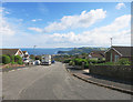
1
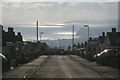
The view down Charlemont Road, Teignmouth
I'd taken one of the town buses for the steep mile up from the town centre to these hillside residential roads, wandered about and was stunned by the views, the reflected sun and the procession of cloud shadows over the sea. In the distance is Thatcher Rock and Hope's Nose, the northern tip of Torbay. Closer to the camera is the Ness across the River Teign, and Teignmouth pier left of centre.
Image: © Robin Stott
Taken: 11 Dec 2012
0.03 miles
2
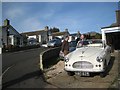
Car talk, Portland Avenue, Teignmouth
Charlemont Road rises in the background. Photographed with permission.
Image: © Robin Stott
Taken: 11 Dec 2012
0.06 miles
3
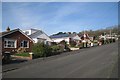
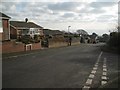
North on Maudlin Drive, Teignmouth
Teignmouth's more recent suburbs are characterised by very steep north-south roads, with level roads connecting them.
Image: © Robin Stott
Taken: 11 Dec 2012
0.06 miles
5
Bend of St David?s Road from Charlemont Road, Teignmouth
This estate has lots of bungalows.
Image: © Robin Stott
Taken: 11 Dec 2012
0.07 miles
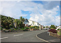
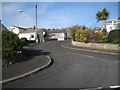
6
Corner of Maudlin Drive and Elm Grove, Teignmouth
One wonders how much further up this steep hillside the estates will be allowed to go. The view is from the corner of St David's Road. Postbox number TQ14 17 is in view.
Image: © Robin Stott
Taken: 11 Dec 2012
0.10 miles
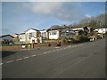
7
At the top of Maudlin Drive
Quite a slog back up here from downtown, but I guess the views make up for it.
Image: © Des Blenkinsopp
Taken: 17 Jun 2016
0.10 miles
8
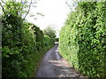
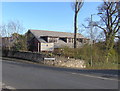
The last house in Higher Woodway Road
Eaves just visible over the hedge, left.
Image: © Robin Stott
Taken: 17 May 2009
0.10 miles
9
Looking down Higher Woodway Road, Teignmouth
Image: © Robin Stott
Taken: 11 Dec 2012
0.11 miles
10
Trinity School, Teignmouth
An independent co-educational school founded 1979 with over 630 pupils from nursery to sixth form, see http://www.trinityschool.co.uk/ and the "development" section.
Image: © Jennifer Vaughan
Taken: 8 Feb 2006
0.13 miles