IMAGES TAKEN NEAR TO
Winston Court, TEIGNMOUTH, TQ14 8QE
Introduction
This page details the photographs taken nearby to Winston Court, TQ14 8QE by members of the Geograph project.
The Geograph project started in 2005 with the aim of publishing, organising and preserving representative images for every square kilometre of Great Britain, Ireland and the Isle of Man.

There are currently over 7.5m images from over14,400 individuals and you can help contribute to the project by visiting https://www.geograph.org.uk
Image Map (Loading...)


Getting Data...Please wait
Leaflet Map data © OpenStreetMap
Images are licensed for reuse under creativecommons.org/licenses/by-sa/2.0
Notes
- Clicking on the map will re-center to the selected point.
- The higher the marker number, the further away the image location is from the centre of the postcode.
Image Listing (156 Images Found)
Images are licensed for reuse under creativecommons.org/licenses/by-sa/2.0
Image
Details
Distance
1
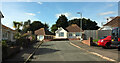
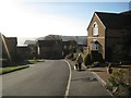
Winston Court, Teignmouth
Taken from Grove Court, which is really just an extension of Winston Court.
Image: © Derek Harper
Taken: 17 Sep 2022
0.01 miles
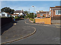
2
Winston Court, Teignmouth
The cul-de-sac on the left of Image
Image: © Derek Harper
Taken: 17 Sep 2022
0.01 miles
3
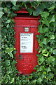
Postbox, Winston Court, Teignmouth
This Elizabeth II postbox, TQ14 46, is at the corner with Churchill Drive, and so just left of the camera in Image
Image: © Derek Harper
Taken: 17 Sep 2022
0.03 miles
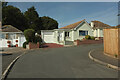
4
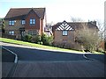
Churchill Drive, Teignmouth
A cul-de-sac with another cul-de-sac, Winston Court, branching off it to the left.
Image: © Derek Harper
Taken: 17 Sep 2022
0.03 miles
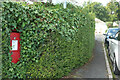
5
Postbox, Winston Court, Teignmouth
A close view of Elizabeth II postbox TQ14 46 Image], embedded in the hedge. I'm sure there's a wall behind it, but I like the way it seems to be part of the ivy, which must be regularly clipped to avoid it disappearing.
Image: © Derek Harper
Taken: 17 Sep 2022
0.04 miles
6
A glimpse of the Ness from Highgrove Park, Teignmouth
The ingredients of a sort of paradise for some: a dog, a block-paved drive, dwarf conifers in pots, a glimpse of the sea. A sea view is sought after, I have no doubt.
Image: © Robin Stott
Taken: 10 Dec 2012
0.07 miles
7
Houses at the junction of Abbey Close and Highgrove Park, Teignmouth
Highgrove Park is the spine road of a residential development on a steep hillside. The relative positions of these two houses show how steep. Between them is a glimpse of St Scholastica's, a former Benedictine nunnery converted to apartments.
Image: © Robin Stott
Taken: 10 Dec 2012
0.08 miles
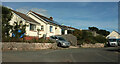
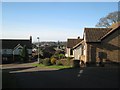
8
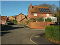
Highgrove Park, Teignmouth
From the southern end of the cul-de-sac, beside a path which connects it to Dawlish Road.
Image: © Derek Harper
Taken: 12 Jan 2022
0.08 miles
9
Alandale Road, Teignmouth
A short steep residential road of bungalows, supervised by an older, thatched house at the top (just in SX9474). It may be called 'Old Landscore' according to an inscribed slate nameplate in the front wall. The name Landscore also occurs in Landscore Road, some distance away: an older road along the contours, lined with villas.
Image: © Robin Stott
Taken: 15 Sep 2014
0.09 miles
10
Western end of Benedict Close, Teignmouth
Benedict Close is a couple of closes off Highgrove Park, residential development on a steep hillside. A former hedgerow oak has been retained, upper right, revealing the puny scle of the houses. There is a glimpse of older development among the now-mature evergreen trees planted by the Victorians. In the far distance is southern Dartmoor.
Image: © Robin Stott
Taken: 10 Dec 2012
0.09 miles