IMAGES TAKEN NEAR TO
Clay Lane, TEIGNMOUTH, TQ14 8FX
Introduction
This page details the photographs taken nearby to Clay Lane, TQ14 8FX by members of the Geograph project.
The Geograph project started in 2005 with the aim of publishing, organising and preserving representative images for every square kilometre of Great Britain, Ireland and the Isle of Man.

There are currently over 7.5m images from over14,400 individuals and you can help contribute to the project by visiting https://www.geograph.org.uk
Image Map
Images are licensed for reuse under creativecommons.org/licenses/by-sa/2.0
Notes
- Clicking on the map will re-center to the selected point.
- The higher the marker number, the further away the image location is from the centre of the postcode.
Image Listing (920 Images Found)
Images are licensed for reuse under creativecommons.org/licenses/by-sa/2.0
Image
Details
Distance
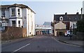
1

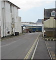
Planning Application site off Clay Lane, Teignmouth
Proposal is for 20 apartments with parking and access: application ref 14/01918/MAJ. Photographed 8 July 2014. No decision had been made at the time of submitting photo, 6 October 2014. The adjoining site, the telephone exchange, left, is also the subject of a planning application.
Image: © Robin Stott
Taken: 8 Jul 2014
0.00 miles
2
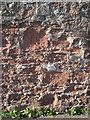
Eroded Teignmouth breccia in a wall
There are some small pieces of pale grey Devonian limestone in the wall as well. These walls of local stone have enormous character. This one bounds the footpath between Clay Lane and Willow Street, perched above the railway cutting.
Image: © Robin Stott
Taken: 14 Sep 2011
0.01 miles
3
Teignmouth Telephone Exchange from the back
With discarded cable reels. The tree on the left appears to be a Holm Oak; in this part of the world they are almost weeds.
Image: © Robin Stott
Taken: 6 Jul 2013
0.01 miles
4
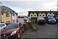
Small car park and footpath off Parson St
Image: © N Chadwick
Taken: 28 Dec 2017
0.02 miles
5
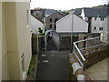
Willow Street approach to footbridge, Teignmouth
The footbridge is almost enclosed in a cage as it crosses the deep railway cutting that slices through Teignmouth. The grey former fish store and prison beyond is now the premises of a funeral director. The footpath going right by the street light runs by the railway to Clay Lane. The bridge crosses the 73 gridline as well as the railway. A better-lit view is Image
Image: © Robin Stott
Taken: 20 May 2009
0.02 miles
6
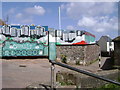
Mural, Clay Lane, Teignmouth
The path, right, runs along the top of the railway cutting to the Willow Street footbridge. The steps, foreground, lead down to Alexandra Terrace.
Image: © Robin Stott
Taken: 19 May 2009
0.02 miles
7
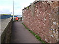
Walls beside a footpath along the railway cutting, Teignmouth
Fine walls of coarse local sandstone line this well-used path.
Image: © Robin Stott
Taken: 20 May 2009
0.02 miles
8
Clay Lane, Teignmouth
On the south side of Bitton Park Road.
Image: © Jaggery
Taken: 21 Apr 2016
0.02 miles
9
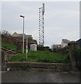
Telecoms mast behind Alexandra Terrace, Teignmouth
Viewed from the eastern end of Alexandra Terrace.
Image: © Jaggery
Taken: 21 Apr 2016
0.02 miles