IMAGES TAKEN NEAR TO
Haytor, NEWTON ABBOT, TQ13 9XS
Introduction
This page details the photographs taken nearby to TQ13 9XS by members of the Geograph project.
The Geograph project started in 2005 with the aim of publishing, organising and preserving representative images for every square kilometre of Great Britain, Ireland and the Isle of Man.

There are currently over 7.5m images from over14,400 individuals and you can help contribute to the project by visiting https://www.geograph.org.uk
Image Map
Images are licensed for reuse under creativecommons.org/licenses/by-sa/2.0
Notes
- Clicking on the map will re-center to the selected point.
- The higher the marker number, the further away the image location is from the centre of the postcode.
Image Listing (40 Images Found)
Images are licensed for reuse under creativecommons.org/licenses/by-sa/2.0
Image
Details
Distance
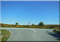
1
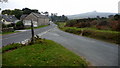
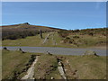
Road junction - B3387
B3387 exits bottom left, with a minor road joining from bottom right. Haytor Rocks clearly visible on the skyline.
Image: © Mike Dodman
Taken: 19 Sep 2009
0.04 miles
2
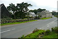
Farm at Haytor Vale
A bit of a tricky spot to exit I should imagine, with a blind spot to the left by the barn and a lane opposite, all used by tourists trying to find the car park and boy racers.
Image: © Graham Horn
Taken: 31 Aug 2012
0.04 miles
3
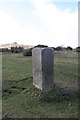
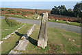
Old Guide Stone by the B3387, Ludgate Barns, Haytor Down
Dartmoor granite guidepost by the B3387, in parish of Ilsington (Teignbridge District), Haytor Down; Haytor Vale turn, 30m West of minor road to Manaton, on grass verge, well back from road, close to path.
Inscription once read:-
South-west side: TO WIDECOMBE : North-west side: TO MANATON : North-east side: TO BOVEY : South-east side: TO ASHBURTON :
Grade II listed. List Entry Number: 1260900
https://historicengland.org.uk/listing/the-list/list-entry/1260900
Surveyed
Milestone Society National ID: DV_XILS02
Image: © Alan Rosevear
Taken: 7 Mar 2012
0.05 miles
4
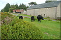
Cattle at Haytor Vale
This is all open access land, and the cattle interpret that as 'we'll graze anywhere, especially on the roadside verges'.
Image: © Graham Horn
Taken: 31 Aug 2012
0.07 miles
5
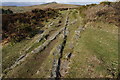
Haytor granite railway
The granite setts of the railway crossing the Manaton road. Haytor rocks are in the background. This unique railway was built in 1820 to transport stone from Haytor quarries to the Stover canal, a distance of some 10 miles.
Image: © Alan Hunt
Taken: 13 Mar 2011
0.07 miles
6
Ilsington: by the road to Beckaford
The Haytor Granite Tramway once crossed the road here. It then heads downhill by the road to Bovey Tracey and disappears into Yarner Wood on its way to Ventiford wharf on the Stover Canal. For more on the tramway see Image In Ilsington parish
Image: © Martin Bodman
Taken: 13 Oct 2010
0.09 miles
7
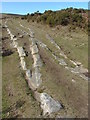
Haytor granite railway
A close up of the setts making up the junction to the east of the Manaton road.
Image: © Alan Hunt
Taken: 13 Mar 2011
0.09 miles
8
Points system, Granite Tramway
From this point on there was two sets of rails heading towards the quarries below Haytor, which can be seen in the distance.
Image: © jeff collins
Taken: 1 Apr 2015
0.10 miles
10
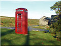
Moorland phone box, Haytor
The phone box at the junction of the road to Haytor Vale with the Haytor Road
Image: © Alan Hunt
Taken: 24 Nov 2014
0.11 miles