IMAGES TAKEN NEAR TO
Carpenter Drive, NEWTON ABBOT, TQ13 9TU
Introduction
This page details the photographs taken nearby to Carpenter Drive, TQ13 9TU by members of the Geograph project.
The Geograph project started in 2005 with the aim of publishing, organising and preserving representative images for every square kilometre of Great Britain, Ireland and the Isle of Man.

There are currently over 7.5m images from over14,400 individuals and you can help contribute to the project by visiting https://www.geograph.org.uk
Image Map
Images are licensed for reuse under creativecommons.org/licenses/by-sa/2.0
Notes
- Clicking on the map will re-center to the selected point.
- The higher the marker number, the further away the image location is from the centre of the postcode.
Image Listing (71 Images Found)
Images are licensed for reuse under creativecommons.org/licenses/by-sa/2.0
Image
Details
Distance
1
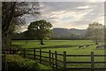
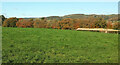
Cattle pasture by Monks Way
From the same spot as Image], looking to the right, with evening sunlight.
Image: © Derek Harper
Taken: 26 Apr 2015
0.06 miles
2
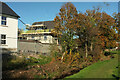
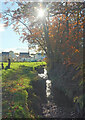
Stream and new houses, Longston Cross
Looking back down Bovey Tracey Footpath 8 as shown in Image], with houses springing up on the northwest side of the stream.
Image: © Derek Harper
Taken: 14 Nov 2021
0.07 miles
3
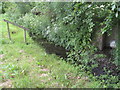
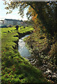
Steps down to the brook
It is difficult to see, but the wooden structure is a handrail beside wooden steps set in the bank and lead down to the brook.
First thoughts might suggest that the steps were to help children get down easily into the brook for a paddle. The clue to the likely answer is the field drainage outlet shown on the right of the picture.
So on second thoughts, the steps down with the wooden handrail must be to enable workmen to safely get down into the brook to clear any blockage to the drain to help avoid a back-up of water and possible flooding issues in the field. Image
The steps might be something to do with Health and Safety issue for the workmen.
Image: © Colin Vosper
Taken: 25 May 2011
0.07 miles
4
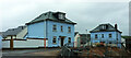
New houses, Longston Cross
These can be seen on the right of Image No street name yet appears on maps.
Image: © Derek Harper
Taken: 20 Feb 2022
0.08 miles
5
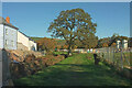
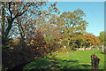
Field near Challabrook Farm
Autumnal trees line the far end of this field by Bovey Tracey Footpath 8. On the right are gravel heaps associated with the construction work at Longston Cross.
Image: © Derek Harper
Taken: 14 Nov 2021
0.08 miles
6
Stream, Longston Cross
Looking upstream with Bovey Tracey Footpath 8 on the left and part of the new housing development at Longston Cross.
Image: © Derek Harper
Taken: 14 Nov 2021
0.08 miles
7
Stream, Longston Cross
Bovey Tracey Footpath 8 and the stream continue to run together a little upstream from Image
Image: © Derek Harper
Taken: 14 Nov 2021
0.08 miles
8
Footpath, Longston Cross
Bovey Tracey Footpath 8, seen looking in the other direction from Image], with the house and tree shown in Image
Image: © Derek Harper
Taken: 14 Nov 2021
0.08 miles
9
Path, Longston Cross
A reverse view of Image], with Bovey Tracey Footpath 8 running alongside the stream towards the A382. The wooded handrail discussed at Image can be seen in the centre.
Image: © Derek Harper
Taken: 14 Nov 2021
0.08 miles
10
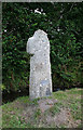
Old Wayside Cross near Challabrook Farm, Bovey Tracey
Cavalier Cross (Longstone or Challabrook Cross), old head, shaft and base, Starkey No.80 by the green lane, in parish of Bovey Tracey (Teignbridge District), on the public footpath leading from the by-pass, about 350m North East of Challabrook Farm, in the grass beside the brook, just before the farm gate.
Grade II listed. List Entry Number: 1165056
https://historicengland.org.uk/listing/the-list/list-entry/1165056
Surveyed
Milestone Society National ID: DVTE_BOV01.
Image: © Alan Rosevear
Taken: 14 Aug 2009
0.08 miles