IMAGES TAKEN NEAR TO
Hennock, Bovey Tracey, NEWTON ABBOT, TQ13 9PZ
Introduction
This page details the photographs taken nearby to TQ13 9PZ by members of the Geograph project.
The Geograph project started in 2005 with the aim of publishing, organising and preserving representative images for every square kilometre of Great Britain, Ireland and the Isle of Man.

There are currently over 7.5m images from over14,400 individuals and you can help contribute to the project by visiting https://www.geograph.org.uk
Image Map
Images are licensed for reuse under creativecommons.org/licenses/by-sa/2.0
Notes
- Clicking on the map will re-center to the selected point.
- The higher the marker number, the further away the image location is from the centre of the postcode.
Image Listing (29 Images Found)
Images are licensed for reuse under creativecommons.org/licenses/by-sa/2.0
Image
Details
Distance
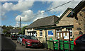
1
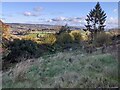
View across the Teign valley from Hennock
Image: © Rob Purvis
Taken: 21 Nov 2021
0.05 miles
2
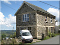
Shute House, Hennock
Hennock is perched on a steep hillside with amazing views. The walls of Shute House are of three materials: the local cream-coloured brick and two stones: the light-coloured granite and a darker stone seen locally, assumed to be volcanic. More of the context is seen in Image
Image: © Robin Stott
Taken: 25 Aug 2011
0.10 miles
3
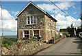
Shute House, Hennock
Duplicating Robin's image at Image, but perhaps the sunlight on the end wall may enhance his fine description of the building materials involved.
Image: © Derek Harper
Taken: 25 Apr 2019
0.10 miles
4
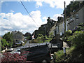
Houses, Hennock
Hennock clings to a steep hillside. The street nameplate below the row on the right says Hazel Crest.
Image: © Robin Stott
Taken: 25 Aug 2011
0.12 miles
5
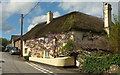
Lowertown Farmhouse, Hennock
Attractively draped in wisteria, this L-shaped thatched farmhouse is described at https://historicengland.org.uk/listing/the-list/list-entry/1097385 . On the left is Hennock Community Primary School.
Image: © Derek Harper
Taken: 25 Apr 2019
0.13 miles
6
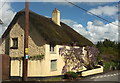
Lowertown Farmhouse, Hennock
A view of Image] from up the road, slightly less obscured by wisteria. described at https://historicengland.org.uk/listing/the-list/list-entry/1097385
Image: © Derek Harper
Taken: 25 Apr 2019
0.13 miles
7
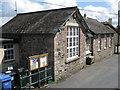
Hennock Primary School
Looking down on it from the children's playground. The walls are of four materials: a local orange brick and two stones: the light-coloured granite and a darker stone seen locally, assumed to be volcanic; the lintels and window cills look like modern concrete.
Image: © Robin Stott
Taken: 25 Aug 2011
0.15 miles
9
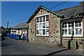
Primary School, Hennock
Hennock Community Primary School occupies different buildings along the village street.
Image: © Derek Harper
Taken: 25 Apr 2019
0.16 miles
10
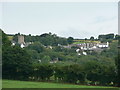
Hennock village and church
Taken from the direction of Warmhill Farm.
Image: © paul dickson
Taken: 8 Jul 2008
0.16 miles