IMAGES TAKEN NEAR TO
Hennock, Bovey Tracey, NEWTON ABBOT, TQ13 9PX
Introduction
This page details the photographs taken nearby to TQ13 9PX by members of the Geograph project.
The Geograph project started in 2005 with the aim of publishing, organising and preserving representative images for every square kilometre of Great Britain, Ireland and the Isle of Man.

There are currently over 7.5m images from over14,400 individuals and you can help contribute to the project by visiting https://www.geograph.org.uk
Image Map
Images are licensed for reuse under creativecommons.org/licenses/by-sa/2.0
Notes
- Clicking on the map will re-center to the selected point.
- The higher the marker number, the further away the image location is from the centre of the postcode.
Image Listing (6 Images Found)
Images are licensed for reuse under creativecommons.org/licenses/by-sa/2.0
Image
Details
Distance
1
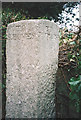
Old Guide Stone at Five Lanes Cross, Stickwick Hill, Hennock
Dartmoor granite guidepost by the UC road, in parish of Hennock (Teignbridge District), Five Lanes Cross, just off Stickwick Hill, a quarter mile South of Hennock; junction to Warmhill, in hedgerow on grass bank.
Inscription reads:-
South-west side: TO / S. BOVEY, North-west side: TO / MORETON, North-east side: TO / HENNOCK, East side: TO / EXETER, South-east side: TO / CHUDLEIGH.
Grade II listed. List Entry Number: 1165927
https://historicengland.org.uk/listing/the-list/list-entry/1165927
Surveyed
Milestone Society National ID: DV_XHEN01.
Image: © Tim Jenkinson
Taken: Unknown
0.14 miles
2
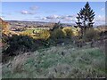
View across the Teign valley from Hennock
Image: © Rob Purvis
Taken: 21 Nov 2021
0.21 miles
3
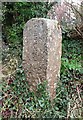
Old Guide Stone south of Hennock
Dartmoor granite guidepost by the UC road, in parish of Hennock (Teignbridge District), Shameface Lane, Y-junction with old dirt lane, on bank above junction.
Inscription reads:-
: TO / CHUDLEIGH : : TO / HENNOCK : : TO / ?? :
Surveyed
Milestone Society National ID: DV_XHEN07
Image: © Alan Rosevear
Taken: 28 Jan 2013
0.24 miles
4

Bridleway near Hennock
Looking north-west up this old track climbing steeply from the Five Lanes junction. Ramsons growing in abundance.
Image: © Derek Harper
Taken: 13 Apr 2006
0.24 miles
5
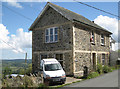
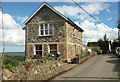
Shute House, Hennock
Hennock is perched on a steep hillside with amazing views. The walls of Shute House are of three materials: the local cream-coloured brick and two stones: the light-coloured granite and a darker stone seen locally, assumed to be volcanic. More of the context is seen in Image
Image: © Robin Stott
Taken: 25 Aug 2011
0.24 miles
6
Shute House, Hennock
Duplicating Robin's image at Image, but perhaps the sunlight on the end wall may enhance his fine description of the building materials involved.
Image: © Derek Harper
Taken: 25 Apr 2019
0.24 miles