IMAGES TAKEN NEAR TO
Bovey Tracey, NEWTON ABBOT, TQ13 9NY
Introduction
This page details the photographs taken nearby to TQ13 9NY by members of the Geograph project.
The Geograph project started in 2005 with the aim of publishing, organising and preserving representative images for every square kilometre of Great Britain, Ireland and the Isle of Man.

There are currently over 7.5m images from over14,400 individuals and you can help contribute to the project by visiting https://www.geograph.org.uk
Image Map
Images are licensed for reuse under creativecommons.org/licenses/by-sa/2.0
Notes
- Clicking on the map will re-center to the selected point.
- The higher the marker number, the further away the image location is from the centre of the postcode.
Image Listing (44 Images Found)
Images are licensed for reuse under creativecommons.org/licenses/by-sa/2.0
Image
Details
Distance
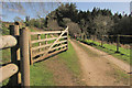
1
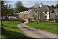
Lower Elsford
Bovey Tracey footpath 36 follows the drive to skirt the farmhouse on the left; this is from where it parts from Bovey Tracey footpath 21.
Image: © Derek Harper
Taken: 16 Mar 2020
0.01 miles
2
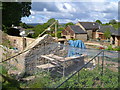
Lower Elsford
Farm buildings under conversion and already converted at this farm, situated on a couple of footpaths that drop from the reservoirs plateau into the Wray Brook valley.
Image: © Derek Harper
Taken: 29 May 2006
0.03 miles
3
At Lower Elsford
Bovey Tracey Footpath 21 follows this track past newly converted buildings; the nearer one is shown under reconstruction in Image
Image: © Derek Harper
Taken: 2 May 2009
0.04 miles
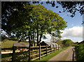
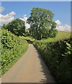
4
Farm road, Lower Elsford
The road leading away from Lower Elsford Farm towards the lane along the ridge northeast of the Wray valley.
Image: © Derek Harper
Taken: 2 May 2009
0.08 miles
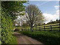
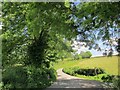
5
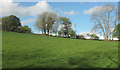
Meadow, Lower Elsford
Image: © Derek Harper
Taken: 25 Apr 2019
0.09 miles
6
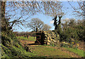
Gate into field near Lower Elsford
From Bovey Tracey footpath 21.
Image: © Derek Harper
Taken: 16 Mar 2020
0.10 miles
7
Track near Lower Elsford
The track shown in Image] has turned a hairpin, but no longer carries Bovey Tracey footpath 21, which I am just about to follow down through Greathill Copse to the left.
Image: © Derek Harper
Taken: 16 Mar 2020
0.11 miles
8
Ash near Lower Elsford
The ash that dominates the junction shown in Image, where the farm lane into Lower Elsford turns off to the right.
Image: © Derek Harper
Taken: 5 Jun 2014
0.11 miles
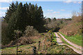
9
Footpath near Lower Elsford
Bovey Tracey footpath 21, seen looking right from Image], descending to Greathill Copse and about to become rather less gentle than seen here.
Image: © Derek Harper
Taken: 16 Mar 2020
0.12 miles
10
Lane at Elsford
The footpath sign points down the farm lane shown in Image, followed by Bovey Tracey Footpath 21. Image] and Image] were taken looking to the left here, on either side of the field boundary that heads up the stream.
Image: © Derek Harper
Taken: 5 Jun 2014
0.12 miles