IMAGES TAKEN NEAR TO
Furzeleigh Lane, NEWTON ABBOT, TQ13 9LU
Introduction
This page details the photographs taken nearby to Furzeleigh Lane, TQ13 9LU by members of the Geograph project.
The Geograph project started in 2005 with the aim of publishing, organising and preserving representative images for every square kilometre of Great Britain, Ireland and the Isle of Man.

There are currently over 7.5m images from over14,400 individuals and you can help contribute to the project by visiting https://www.geograph.org.uk
Image Map
Images are licensed for reuse under creativecommons.org/licenses/by-sa/2.0
Notes
- Clicking on the map will re-center to the selected point.
- The higher the marker number, the further away the image location is from the centre of the postcode.
Image Listing (29 Images Found)
Images are licensed for reuse under creativecommons.org/licenses/by-sa/2.0
Image
Details
Distance
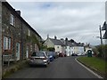
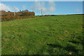
1
Field by Furzeleigh Lane
Looking in the other direction from Image], with a house on the lane indicating the start of Bovey Tracey.
Image: © Derek Harper
Taken: 21 Nov 2021
0.02 miles
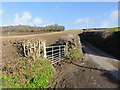
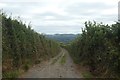
2
Track from Furzeleigh Lane
A private track to Whitstone Farm.
Image: © Derek Harper
Taken: 21 Nov 2021
0.05 miles
3
Furzeleigh Lane
Looking uphill towards Furzeleigh Plantation. This lane is steeper than it looks.
Image: © Tony Atkin
Taken: 27 Jan 2013
0.11 miles
4
Field by Furzeleigh Lane
From Bovey Tracey footpath 5, with the roadside hedge on Furzeleigh Lane, and Bearacleave Wood on the crest of the hill.
Image: © Derek Harper
Taken: 21 Nov 2021
0.11 miles
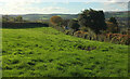
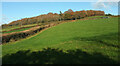
5
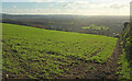
Farmland at Furzeleigh Lane
After a long climb up from Bovery Tracey, we stopped for a rest here and had a good, if hazy, view back to the town where we had started our walk. I presume something is sown in this field that has not yet started to poke through.
Image: © Graham Horn
Taken: 15 Apr 2013
0.13 miles
6
Track (right of way) with views towards Stover
Image: © David Smith
Taken: 15 Jul 2020
0.14 miles
7
Field by Furzeleigh Lane
On the left, the double hedge marks the line of the green lane shown in Image In the centre it joins Furzeleigh Lane to climb to Bearacleave Wood.
Image: © Derek Harper
Taken: 21 Nov 2021
0.16 miles
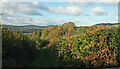
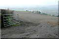
8
Field above Bovey Tracey
Looking right from Image] over the eastern suburbs of the town and the Bovey valley.
Image: © Derek Harper
Taken: 21 Nov 2021
0.16 miles
9
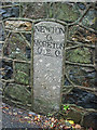
Old Milestone by Mary Street, Bovey Tracey
Carved stone post by the UC road (was A382), in parish of BOVEY TRACEY (TEIGNBRIDGE District), Mary Street, 50m from turn to Hospital, built into wall, on Northwest side of road. Newton detail granite square, erected by the Newton Bushell turnpike trust in the 19th century.
Inscription reads:-
NEWTON
6.
-------
MORETON
6.2.0.
-------
Milestone Society National ID: DV_NAMN06.
Image: © T Jenkinson
Taken: 27 Nov 2006
0.17 miles