IMAGES TAKEN NEAR TO
Southbrook Close, NEWTON ABBOT, TQ13 9GL
Introduction
This page details the photographs taken nearby to Southbrook Close, TQ13 9GL by members of the Geograph project.
The Geograph project started in 2005 with the aim of publishing, organising and preserving representative images for every square kilometre of Great Britain, Ireland and the Isle of Man.

There are currently over 7.5m images from over14,400 individuals and you can help contribute to the project by visiting https://www.geograph.org.uk
Image Map
Images are licensed for reuse under creativecommons.org/licenses/by-sa/2.0
Notes
- Clicking on the map will re-center to the selected point.
- The higher the marker number, the further away the image location is from the centre of the postcode.
Image Listing (11 Images Found)
Images are licensed for reuse under creativecommons.org/licenses/by-sa/2.0
Image
Details
Distance
1
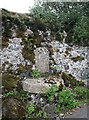
Old Wayside Cross by Cross Cottage, Mary Street, Bovey Tracey
Bovey Stone, old shaft and base, Starkey No.77 by the UC road, in parish of Bovey Tracey (Teignbridge District), in the boundary wall of Cross Cottage, Mary Street, opposite Furzeleigh Lane junction, on a rubble plinth.
Grade II listed.
List Entry Number: 1165795 https://historicengland.org.uk/listing/the-list/list-entry/1165795
Surveyed
Milestone Society National ID: DVTE_BOV02
Image: © Alan Rosevear
Taken: 14 Aug 2009
0.11 miles
2
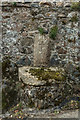
The Bovey Stone
Set in the wall of Cross Cottage.
See https://historicengland.org.uk/listing/the-list/list-entry/1165795
Image: © Guy Wareham
Taken: 7 Oct 2018
0.11 miles
3
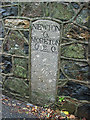
Old Milestone by Mary Street, Bovey Tracey
Carved stone post by the UC road (was A382), in parish of BOVEY TRACEY (TEIGNBRIDGE District), Mary Street, 50m from turn to Hospital, built into wall, on Northwest side of road. Newton detail granite square, erected by the Newton Bushell turnpike trust in the 19th century.
Inscription reads:-
NEWTON
6.
-------
MORETON
6.2.0.
-------
Milestone Society National ID: DV_NAMN06.
Image: © T Jenkinson
Taken: 27 Nov 2006
0.14 miles
5
Monks Way - exiting Bovey Tracey
Heading into Dartmoor National Park.
Image: © Fernweh
Taken: 15 Mar 2014
0.20 miles
7
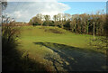
Meadow near Hole Bridge
A view from the Dartmoor Way and Wray Valley Trail on the former railway. The trees on the right obscure the A382 Monks Way. Frost remains around the shadow of nearby trees.
Image: © Derek Harper
Taken: 31 Dec 2020
0.21 miles
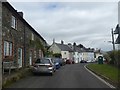
8
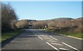
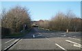
A382; the end of the by-pass of Bovey Tracey
At the junction ahead, the road on the right leads from the former main road to Moretonhampstead and former route of the A382. The road is a slip road, so that the junction is at right angles to the new road, and about 200 metres of the old route is now disused and closed off
Image: © David Smith
Taken: 31 Oct 2014
0.23 miles
10
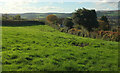
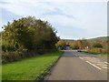
Field by Furzeleigh Lane
Looking in the other direction from Image], with a house on the lane indicating the start of Bovey Tracey.
Image: © Derek Harper
Taken: 21 Nov 2021
0.25 miles