IMAGES TAKEN NEAR TO
Drake Lane, NEWTON ABBOT, TQ13 9FX
Introduction
This page details the photographs taken nearby to Drake Lane, TQ13 9FX by members of the Geograph project.
The Geograph project started in 2005 with the aim of publishing, organising and preserving representative images for every square kilometre of Great Britain, Ireland and the Isle of Man.

There are currently over 7.5m images from over14,400 individuals and you can help contribute to the project by visiting https://www.geograph.org.uk
Image Map
Images are licensed for reuse under creativecommons.org/licenses/by-sa/2.0
Notes
- Clicking on the map will re-center to the selected point.
- The higher the marker number, the further away the image location is from the centre of the postcode.
Image Listing (131 Images Found)
Images are licensed for reuse under creativecommons.org/licenses/by-sa/2.0
Image
Details
Distance
1
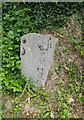
Old Guide Stone by Coombe Cross, Bradley Road, Bovey Tracey
Dartmoor granite guidepost by the UC road, in parish of Bovey Tracey (Teignbridge District), Coombe Cross, Bradley Road, junction with Combe Lane, on bank at junction.
Inscription reads:-
: TO / HENNOCK : : TO / BOVEY : : TO / CHUDLEIGH / {arrow->} :
Grade II listed.
List Entry Number: 1165699 https://historicengland.org.uk/listing/the-list/list-entry/1165699
Surveyed
Milestone Society National ID: DV_XBOV04
Image: © Alan Rosevear
Taken: 20 Jul 2012
0.05 miles
2
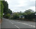
Bus shelter in Bradley Road, Bovey Tracey
Image: © David Smith
Taken: 15 Jul 2020
0.05 miles
3
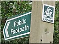
Bovey Tracey - Footpath Sign
Signpost on East Street with sign for Public Footpath and a maritime-themed plaque for Devon.
Image: © Colin Smith
Taken: 24 Jul 2021
0.11 miles
4
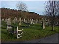
Bovey Tracey cemetery
The cemetery extension off Coombe Lane, Bovey Tracey. Coombe Plantation is in the background
Image: © Alan Hunt
Taken: 1 Mar 2010
0.14 miles
5
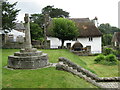
Bovey Tracey - Churchyard Cross
The parish church is St Peter, St Paul, and St Thomas of Canterbury (PPT) and a church has been on this hilltop site since the 10th century. The cross stands to the south of the church, facing East Street.
www.boveytracey.gov.uk
Image: © Colin Smith
Taken: 24 Jul 2021
0.14 miles
6
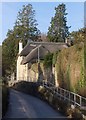
Cottage, Bovey Tracey
A reverse view of Image looking up Bradley Road to the thatched Church Steps, with a raised pavement on the right.
Image: © Derek Harper
Taken: 12 Dec 2010
0.14 miles
7
The Oaks, Bovey Tracey
It may be a housing estate, but the curve in the cul-de-sac provides a pleasing element. The no cycling sign refers to cycling on the pavement, as the path along the B3344 Le Molay-Littry Way immediately behind the camera must be multi-use.
Image: © Derek Harper
Taken: 14 Nov 2021
0.15 miles
8
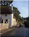
Cottage, Bovey Tracey
Church Steps, also shown in Image, is the former church house, on the south side of the churchyard of Image Bradley Road passes by it on the right.
Image: © Derek Harper
Taken: 12 Dec 2010
0.15 miles
9
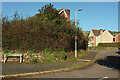
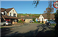
Churchfields Drive, Bovey Tracey
At the eastern junction with the B3344. The estate road winds around a good deal before rejoining Le Molay-Littry Way some 150 metres west.
Image: © Derek Harper
Taken: 14 Nov 2021
0.15 miles
10
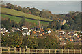
Bovey Tracey from Chapple Road
A detail of Image The large building to the right of the church is Devon House, originally the Devon House of Mercy. In the foreground is a walker on Bovey Tracey Footpath 8. Taken from the Templer Way.
Image: © Derek Harper
Taken: 14 Nov 2021
0.15 miles