IMAGES TAKEN NEAR TO
Blenheim Terrace, NEWTON ABBOT, TQ13 9AT
Introduction
This page details the photographs taken nearby to Blenheim Terrace, TQ13 9AT by members of the Geograph project.
The Geograph project started in 2005 with the aim of publishing, organising and preserving representative images for every square kilometre of Great Britain, Ireland and the Isle of Man.

There are currently over 7.5m images from over14,400 individuals and you can help contribute to the project by visiting https://www.geograph.org.uk
Image Map
Images are licensed for reuse under creativecommons.org/licenses/by-sa/2.0
Notes
- Clicking on the map will re-center to the selected point.
- The higher the marker number, the further away the image location is from the centre of the postcode.
Image Listing (161 Images Found)
Images are licensed for reuse under creativecommons.org/licenses/by-sa/2.0
Image
Details
Distance
1
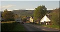
Monks Way, Bovey Tracey
Looking in the other direction along the A382 from the same spot as Image, with the roundabout at the crossroads with the B3387 / 3344 ahead. Monks Way continues straight on, still using the line of the former railway for another 230 metres or so. In the background are the woods on the slopes of Shaptor Down.
Image: © Derek Harper
Taken: 26 Apr 2015
0.02 miles

3
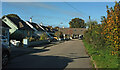
Fairfield Close, Bovey Tracey
A cul-de-sac that converges with the A382 Monks Way, which runs beside the garden in the house at the end.
Image: © Derek Harper
Taken: 14 Nov 2021
0.03 miles
4
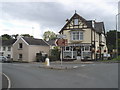
Copper Kettle tearooms, Bovey Tracey
Image: © Roger Cornfoot
Taken: 27 Jul 2009
0.04 miles
5
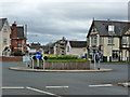
Roundabout, Bovey Tracey
This was the first time I have seen this roundabout and its stone sculpture. I have to admit I immediately christened it the "Jenga roundabout".
Image: © Ruth Sharville
Taken: 8 Apr 2012
0.04 miles
6
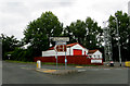
On the A382
Judging by the tall tower I think this is the premises of the local Fire & Rescue service at Bovey Tracey..
Image: © Robert Ashby
Taken: 7 Aug 2015
0.05 miles
7
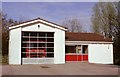
Bovey Tracey Fire Station
Bovey Tracey Fire Station, Marlborough Terrace, Bovey Tracey, Devon.
Image: © Kevin Hale
Taken: 21 Apr 1991
0.05 miles
8
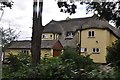
Bovey Tracey : Yellow House
Yellow House alongside the B3387 outside Bovey Tracey.
Image: © Lewis Clarke
Taken: 12 Aug 2013
0.06 miles
9
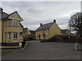
Dartmoor Court, Bovey Tracey
A recent development off Station Road.
Image: © David Hawgood
Taken: 13 Feb 2010
0.06 miles
10
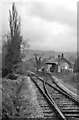
Bovey, for Ilsington Station (remains)
View northward, towards Moretonhampstead; ex-GWR (Newton Abbot) - Heathfield - Moretonhampstead branch. The station and the service to Moretonhampstead was closed on 2/3/59 (goods 6/4/64, but oil was brought to Bovey from Heathfield until 4/5/70).
The station - 'Tracey' in the name - seemed to be still well-preserved in 1964.
Image: © Ben Brooksbank
Taken: 20 Apr 1964
0.07 miles