IMAGES TAKEN NEAR TO
Cossick Cross, NEWTON ABBOT, TQ13 8SN
Introduction
This page details the photographs taken nearby to Cossick Cross, TQ13 8SN by members of the Geograph project.
The Geograph project started in 2005 with the aim of publishing, organising and preserving representative images for every square kilometre of Great Britain, Ireland and the Isle of Man.

There are currently over 7.5m images from over14,400 individuals and you can help contribute to the project by visiting https://www.geograph.org.uk
Image Map
Images are licensed for reuse under creativecommons.org/licenses/by-sa/2.0
Notes
- Clicking on the map will re-center to the selected point.
- The higher the marker number, the further away the image location is from the centre of the postcode.
Image Listing (11 Images Found)
Images are licensed for reuse under creativecommons.org/licenses/by-sa/2.0
Image
Details
Distance
1
Snowdrops near Cossick Cross
In a patch of trees by the lane from Pepperdon Down.
Image: © Derek Harper
Taken: 2 Feb 2013
0.03 miles
2
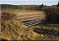
Field by Cossick Cross
A gateway a few metres up the lane across the crossroads shown in Image On the right-hand side of the field is a hedge bordering the B3212. The bump on the horizon just right of centre is Blackingstone Rock.
Image: © Derek Harper
Taken: 2 Feb 2013
0.04 miles
4
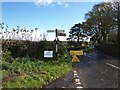
Cossick Cross
The road closure may have been caused by flooding or landslip due to heavy rain, just about to re-start when this picture taken
Image: © David Gearing
Taken: 1 Nov 2012
0.06 miles
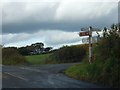
5
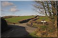
Cossick Cross
This junction at a col on the B3212 has recently become a popular subject http://www.geograph.org.uk/search.php?i=39609851 . The col is between the Doccombe valley and the Wray valley and the B road winds round many bends to reach it, somewhat in the manner of a mountain pass. Here, the lane from Pepperdon Down crosses it, continuing towards Mardon Down.
Image: © Derek Harper
Taken: 2 Feb 2013
0.07 miles
6
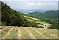
Moretonhampstead: above Doccombe
Looking towards the distant Teign valley from near Cossick Cross, 986 feet above sea level. A side valley runs down from Doccombe to the Teign via Woodcock Wood – in mid-distance – and the Moretonhampstead – Exeter road runs this way
Image: © Martin Bodman
Taken: 4 Jul 1993
0.14 miles
7
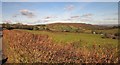
View towards Mardon Down
From the lane between Pepperdon Down and Cossick Cross, looking over Doccombe, with a pasture in the foreground. On the right is Cossick Cross.
Image: © Derek Harper
Taken: 2 Feb 2013
0.15 miles
8
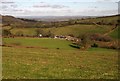
Cossick Farm
From the lane seen in Image], looking down over the Doccombe valley.
Image: © Derek Harper
Taken: 2 Feb 2013
0.16 miles
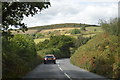
9
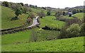
B3212 near Doccombe
The road climbs the valley above Doccombe, towards Cossick Farm.
Image: © Derek Harper
Taken: 2 May 2009
0.21 miles