IMAGES TAKEN NEAR TO
Chagford, NEWTON ABBOT, TQ13 8HQ
Introduction
This page details the photographs taken nearby to TQ13 8HQ by members of the Geograph project.
The Geograph project started in 2005 with the aim of publishing, organising and preserving representative images for every square kilometre of Great Britain, Ireland and the Isle of Man.

There are currently over 7.5m images from over14,400 individuals and you can help contribute to the project by visiting https://www.geograph.org.uk
Image Map
Images are licensed for reuse under creativecommons.org/licenses/by-sa/2.0
Notes
- Clicking on the map will re-center to the selected point.
- The higher the marker number, the further away the image location is from the centre of the postcode.
Image Listing (12 Images Found)
Images are licensed for reuse under creativecommons.org/licenses/by-sa/2.0
Image
Details
Distance
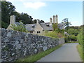
3
Footbridges over the Teign near Holystreet Manor
Image: © Christopher Hilton
Taken: 26 Oct 2014
0.04 miles
4
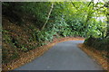
Twisting lane dropping from Leigh Bridge towards Chagford
Image: © Christopher Hilton
Taken: 27 Oct 2014
0.06 miles
5
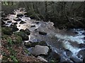
River Teign at Milfordleigh Plantation
Seen from the National Trust woodland on the north side of the river, as it rushes over boulders.
Image: © Derek Harper
Taken: 17 Feb 2013
0.09 miles
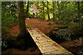
6
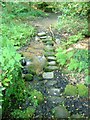
Stepping stones near Murchington
Taking the Taw-Teign Link path (and Throwleigh Footpath 2) across the small tributary of the Teign that occupies the valley shown in Image
Image: © Derek Harper
Taken: 8 Jun 2006
0.12 miles
7
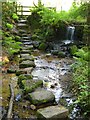
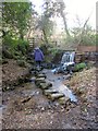
Stepping stones near Murchington
A reverse view of Image, with the small stream dropping over a weir just above the path crossing, and the path (the Taw-Teign Link path following Throwleigh Footpath 2) leading up into Image on the far side. Taken from the edge of War Cleave Wood.
Image: © Derek Harper
Taken: 8 Jun 2006
0.12 miles
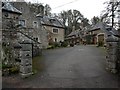
8
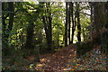
Public footpath, War Cleave Wood
The footpath swings right, whilst beyond the gate is the private Warcleave Cottage.
Image: © Christopher Hilton
Taken: 27 Oct 2014
0.13 miles
9
Stepping stones near Murchington
A winter view of Image, with an increased rate of flow over the weir, but no trouble crossing the stones on Throwleigh Footpath 2 (unlike a little later on the Teign near Leigh Bridge)
Image: © Derek Harper
Taken: 17 Feb 2013
0.17 miles
10
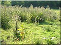
Thistles near Murchington
A stand of marsh thistles (Cirsium palustre) passed by the Taw-Teign Link path following Throwleigh Footpath 2 down the field shown in Image
Image: © Derek Harper
Taken: 8 Jun 2006
0.18 miles