IMAGES TAKEN NEAR TO
Chagford, NEWTON ABBOT, TQ13 8HH
Introduction
This page details the photographs taken nearby to TQ13 8HH by members of the Geograph project.
The Geograph project started in 2005 with the aim of publishing, organising and preserving representative images for every square kilometre of Great Britain, Ireland and the Isle of Man.

There are currently over 7.5m images from over14,400 individuals and you can help contribute to the project by visiting https://www.geograph.org.uk
Image Map
Images are licensed for reuse under creativecommons.org/licenses/by-sa/2.0
Notes
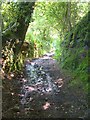
- Clicking on the map will re-center to the selected point.
- The higher the marker number, the further away the image location is from the centre of the postcode.
Image Listing (28 Images Found)
Images are licensed for reuse under creativecommons.org/licenses/by-sa/2.0
Image
Details
Distance
1
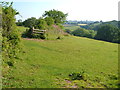
Field boundary near Leigh
From the Two Moors Way following Throwleigh Byway 16. The hillside is dropping towards Image The valley on the right is that of the North Teign.
Image: © Derek Harper
Taken: 8 Jun 2006
0.13 miles
2
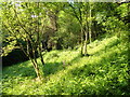
Open woodland by the Two Moors Way
From the Way following Throwleigh Byway 16 down a steep hillside to Leigh Bridge.
Image: © Derek Harper
Taken: 8 Jun 2006
0.14 miles
3
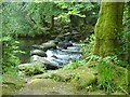
Stepping stones across the North Teign
These carry Throwleigh Bridleway 1 across the river. The bridleway then climbs steeply between walls and beside Midfordleigh Plantation towards Murchington.
Image: © Derek Harper
Taken: 8 Jun 2006
0.14 miles
4
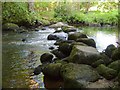
Stepping stones across the North Teign
A reverse view of Image from the other bank, showing the course of Throwleigh Bridleway 1.
Image: © Derek Harper
Taken: 8 Jun 2006
0.14 miles
5
Two Moors Way
The Way descending to Leigh Bridge, sunken in a green lane followed by Throwleigh Byway 16.
Image: © Derek Harper
Taken: 8 Jun 2006
0.14 miles
6
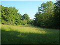
Meadow by the North Teign
A view from the last stretch of the public road (here followed by the Two Moors Way) west of Leigh Bridge, so just west of where Image was taken. The river runs along the right hand side of the meadow. Throwleigh Bridleway 1 follows the drive to Leigh and Gidleigh Park through the trees on the left.
Image: © Derek Harper
Taken: 8 Jun 2006
0.14 miles
7
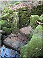
Posts and wall by the stepping stone, River North Teign
A solid-looking landfall at the east side of the stepping stone shown at http://www.geograph.org.uk/search.php?i=39945308 , with sturdy gateposts between walls that line Throwleigh Bridleway 1 as it starts to climb the gully shown in Image However, the stepping stones themselves looked risky this time, so we retraced our steps.
Image: © Derek Harper
Taken: 17 Feb 2013
0.14 miles
8
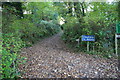
Byway from Leigh Bridge to Teigncombe
Image: © Christopher Hilton
Taken: 27 Oct 2014
0.14 miles
9
Path in Milfordleigh
A path descends from Throwleigh Bridleway 1 through woodland above the River Teign. This wood is owned by the National Trust.
Image: © Derek Harper
Taken: 17 Feb 2013
0.15 miles
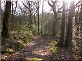
10
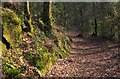
Path, Milfordleigh
Taken further down the path shown in Image] as it descends to the Teign beside mossy rocks.
Image: © Derek Harper
Taken: 17 Feb 2013
0.15 miles