IMAGES TAKEN NEAR TO
Tinners Lane, NEWTON ABBOT, TQ13 8FR
Introduction
This page details the photographs taken nearby to Tinners Lane, TQ13 8FR by members of the Geograph project.
The Geograph project started in 2005 with the aim of publishing, organising and preserving representative images for every square kilometre of Great Britain, Ireland and the Isle of Man.

There are currently over 7.5m images from over14,400 individuals and you can help contribute to the project by visiting https://www.geograph.org.uk
Image Map
Images are licensed for reuse under creativecommons.org/licenses/by-sa/2.0
Notes
- Clicking on the map will re-center to the selected point.
- The higher the marker number, the further away the image location is from the centre of the postcode.
Image Listing (190 Images Found)
Images are licensed for reuse under creativecommons.org/licenses/by-sa/2.0
Image
Details
Distance
1
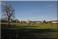
Pasture near Chagford
Looking from the lane to Great Weeke across the fire station (right of centre) and other buildings on the B3206.
Image: © Derek Harper
Taken: 17 Feb 2013
0.05 miles
2
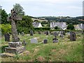
Churchyard, St Michael's Church, Chagford
The churchyard has many old and interesting gravestones and tombs within it.
Image: © Maigheach-gheal
Taken: 8 Jul 2010
0.07 miles
3
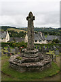
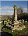
Old Central Cross - moved to Chagford churchyard
War Memorial, old head and base in a new cross, by the footpath, in parish of Chagford (West Devon District), 30m East of Church of St. Michael, in churchyard extension, at central junction of paths (was in Market Place).
Grade II listed.
List Entry Number: 1308621 https://historicengland.org.uk/listing/the-list/list-entry/1308621
Surveyed
Milestone Society National ID: DVWD_CHA02
Image: © Alan Rosevear
Taken: 20 Jul 2011
0.08 miles
4
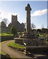
Cross and church, Chagford
Looking up the long path through the churchyard. The cross is described at http://list.english-heritage.org.uk/resultsingle.aspx?uid=1308621&searchtype=mapsearch as " erected as a war memorial in 1928 using fragments of probably C15 crosses ... the head is medieval but the shaft is C20". For the church, see http://list.english-heritage.org.uk/resultsingle.aspx?uid=1308610&searchtype=mapsearch .
Image: © Derek Harper
Taken: 17 Feb 2013
0.08 miles
5
Churchyard cross, Chagford
The cross http://list.english-heritage.org.uk/resultsingle.aspx?uid=1308621&searchtype=mapsearch shown in Image] from the opposite direction. Below the churchyard are houses on Orchard Meadow.
Image: © Derek Harper
Taken: 17 Feb 2013
0.08 miles
6
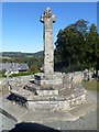
War memorial
Erected in 1928 in the churchyard of the church of St Michael, this cross serves as Chagford's war memorial. The head and socket stone are medieval, the shaft is 20th century. Listed, grade II, with details at: https://historicengland.org.uk/listing/the-list/list-entry/1308621
Image: © Michael Dibb
Taken: 26 Sep 2018
0.08 miles
7
![Parish church [6]](https://s0.geograph.org.uk/geophotos/05/94/51/5945172_cdf13227_120x120.jpg)
Parish church [6]
The churchyard. Several chest tombs and headstones are listed.
The church of St Michael is a 15th rebuild, in Perpendicular style, of an earlier church. There was a major renovation circa 1888 and there are some additions and alterations later. The interior fittings are mostly 19th century. Listed, grade I, with details at: https://historicengland.org.uk/listing/the-list/list-entry/1308610
Image: © Michael Dibb
Taken: 26 Sep 2018
0.09 miles
8
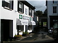
Ludgate Fine Art gallery, Southcombe Street, Chagford
Image: © Rob Purvis
Taken: 3 Sep 2009
0.09 miles
10
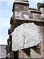
Sundial, St Michael's Church
The slate sundial has a brass pointer and dates from the late 17th or early 18th century.
Sundials or sun clocks are considered to be the oldest known device for the measurement of time and one of the most ancient scientific instruments.
The oldest known true sundial was built around 1500BC in Egypt. Shaped like a letter 'L' the length of the shadow cast by the vertical leg along the horizontal leg indicated the time. The Romans perfected the horizontal sundial we know today and invented portable travelling versions.
Image: © Maigheach-gheal
Taken: 8 Jul 2010
0.11 miles