IMAGES TAKEN NEAR TO
Ashburton, NEWTON ABBOT, TQ13 7NF
Introduction
This page details the photographs taken nearby to TQ13 7NF by members of the Geograph project.
The Geograph project started in 2005 with the aim of publishing, organising and preserving representative images for every square kilometre of Great Britain, Ireland and the Isle of Man.

There are currently over 7.5m images from over14,400 individuals and you can help contribute to the project by visiting https://www.geograph.org.uk
Image Map
Images are licensed for reuse under creativecommons.org/licenses/by-sa/2.0
Notes
- Clicking on the map will re-center to the selected point.
- The higher the marker number, the further away the image location is from the centre of the postcode.
Image Listing (20 Images Found)
Images are licensed for reuse under creativecommons.org/licenses/by-sa/2.0
Image
Details
Distance
1
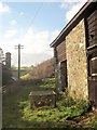
Hens, Baddaford
Baddaford is a very modest hamlet at a road and a byway junction.
Image: © Derek Harper
Taken: 9 Dec 2013
0.02 miles
2
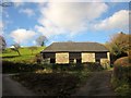
Barn, Baddaford
Seen on the right of Image], with a not very grassy triangle at the lane junction in the foreground. Behind the barn is a small orchard.
Image: © Derek Harper
Taken: 9 Dec 2013
0.02 miles
3
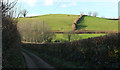
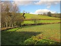
From the lane to Baddaford
In between the spots where Image and Image were taken, with the field boundary climbing the northwestern valley side from the lane to Bulland.
Image: © Derek Harper
Taken: 9 Jan 2019
0.07 miles
4
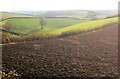
Countryside near Baddaford
From a gateway on the right of Image Baddaford is hidden in the valley.
Image: © Derek Harper
Taken: 9 Dec 2013
0.08 miles
5
Farmland, Baddaford
From the lane to Higher Penn, looking across the valley that runs down to Staverton.
Image: © Derek Harper
Taken: 9 Dec 2013
0.08 miles
6
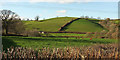
Valley, Baddaford
From the lane from Higher Penn, and five years on from Image The distinctive field boundary climbing the valley side can also be seen in Image
Image: © Derek Harper
Taken: 9 Jan 2019
0.08 miles
7
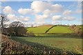
Countryside near Baddaford
From the lane shown in Image], looking to the left, across a similar area of the valley to Image The trees on the right are those enclosing the bridleway shown in http://www.geograph.org.uk/search.php?i=45702072 .
Image: © Derek Harper
Taken: 9 Dec 2013
0.09 miles
8
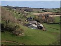
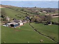
Baddaford
The farmhouse and its buildings sit attractively in the valley of a tributary (draining to the right) of the Dart. Taken from the same spot as Image
Image: © Derek Harper
Taken: 9 Mar 2009
0.13 miles
9
Baddaford
Image: © Derek Harper
Taken: 9 Mar 2009
0.13 miles
10
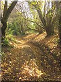
Bridleway to Baddaford
Further down Staverton Bridleway 42 from Image], with a covering of fallen leaves on the ground, but still the narrow central gully.
Image: © Derek Harper
Taken: 9 Dec 2013
0.13 miles