IMAGES TAKEN NEAR TO
Woodland, Ashburton, NEWTON ABBOT, TQ13 7JT
Introduction
This page details the photographs taken nearby to TQ13 7JT by members of the Geograph project.
The Geograph project started in 2005 with the aim of publishing, organising and preserving representative images for every square kilometre of Great Britain, Ireland and the Isle of Man.

There are currently over 7.5m images from over14,400 individuals and you can help contribute to the project by visiting https://www.geograph.org.uk
Image Map
Images are licensed for reuse under creativecommons.org/licenses/by-sa/2.0
Notes
- Clicking on the map will re-center to the selected point.
- The higher the marker number, the further away the image location is from the centre of the postcode.
Image Listing (19 Images Found)
Images are licensed for reuse under creativecommons.org/licenses/by-sa/2.0
Image
Details
Distance
1
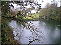
Lake in old slate quarry, Wickeridge
View SSW. At rear, converted outbuildings of Wickeridge House.
Image: © Derek Harper
Taken: 26 Mar 2006
0.02 miles
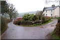
2
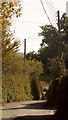
Lane to the Rising Sun
Looking right from where Image was taken. The lane here is followed by the parish boundary between Denbury (left) and Woodland.
Image: © Derek Harper
Taken: 22 Oct 2018
0.12 miles
3
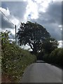
Solitary tree by the road near Wickeridge
The tree is on a bend in the road, close to Wickeridge Lodge
Image: © David Smith
Taken: 4 Oct 2013
0.13 miles
4
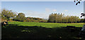
Field, Wickeridge
Taken more or less from beneath the tree shown in Image A new plantation is in the very northeast corner of the square.
Image: © Derek Harper
Taken: 22 Oct 2018
0.15 miles
5
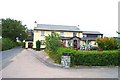
Rising Sun - near Woodlands
A refurbished roadside pub.
Image: © Richard Knights
Taken: 20 Jul 2005
0.16 miles
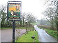
6
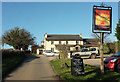
Rising Sun sign, car park and pub
See Image; most of the pub itself is actually in Image, though the right-hand end is in square. A previous illustration on the sign is at Image The road follows the parish boundary between Woodland (left) and Denbury and Torbryan.
Image: © Derek Harper
Taken: 9 Jan 2019
0.18 miles
7
The Rising Sun
The pub is more or less on a gridline. See also Image
Image: © Derek Harper
Taken: 26 Mar 2006
0.18 miles
8
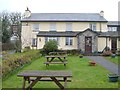
Car park at the Rising Sun Inn, near Woodland
Image: © Ruth Sharville
Taken: 30 Dec 2013
0.18 miles
9
Wickeridge Farm
A more inclusive shot than Image], showing the farm entrance and some daffodils.
Image: © Derek Harper
Taken: 26 Mar 2006
0.19 miles
10
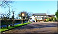
Car park and sign, Rising Sun
The recent Image shows that the sign has changed since this was taken, in position as well as character. The road follows the parish boundary between Woodland (right) and Denbury and Torbryan. See the later Image
Image: © Derek Harper
Taken: 26 Mar 2006
0.20 miles