IMAGES TAKEN NEAR TO
Ashburton, NEWTON ABBOT, TQ13 7HR
Introduction
This page details the photographs taken nearby to TQ13 7HR by members of the Geograph project.
The Geograph project started in 2005 with the aim of publishing, organising and preserving representative images for every square kilometre of Great Britain, Ireland and the Isle of Man.

There are currently over 7.5m images from over14,400 individuals and you can help contribute to the project by visiting https://www.geograph.org.uk
Image Map
Images are licensed for reuse under creativecommons.org/licenses/by-sa/2.0
Notes
- Clicking on the map will re-center to the selected point.
- The higher the marker number, the further away the image location is from the centre of the postcode.
Image Listing (4 Images Found)
Images are licensed for reuse under creativecommons.org/licenses/by-sa/2.0
Image
Details
Distance
1
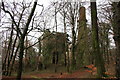
Druid Copper Mine
On private land but visible from the road especially in winter.
Image: © Guy Wareham
Taken: 3 Feb 2010
0.05 miles
2
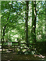
Druid Mine, Ashburton
The remains include an engine house and brick topped chimney. The mine worked intermittently from the 1850s to the 70s for copper. The engine house was enlarged in 1869 to take a 56" engine. It is on private land but can be glimpsed from the road.
Image: © Chris Allen
Taken: 31 Aug 2013
0.06 miles
3
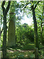
Druid Mine, Ashburton
Seen from the road as it is on private land. The engine house is covered by vegetation in the middle with the chimney to the right. This is a typical 'Cornish' chimney with stone bottom section and brick top. This copper mine worked intermittently between the 1850s and 1870s.
Image: © Chris Allen
Taken: 31 Aug 2013
0.06 miles
4
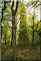
Old mine chimney near Druid
This chimney was part of the Druid Copper Mine works; situated on private land the remains of the pit buildings are clearly visible from the road.
Image: © Guy Wareham
Taken: 25 Oct 2008
0.07 miles