IMAGES TAKEN NEAR TO
St. Lawrence Lane, NEWTON ABBOT, TQ13 7DD
Introduction
This page details the photographs taken nearby to St. Lawrence Lane, TQ13 7DD by members of the Geograph project.
The Geograph project started in 2005 with the aim of publishing, organising and preserving representative images for every square kilometre of Great Britain, Ireland and the Isle of Man.

There are currently over 7.5m images from over14,400 individuals and you can help contribute to the project by visiting https://www.geograph.org.uk
Image Map
Images are licensed for reuse under creativecommons.org/licenses/by-sa/2.0
Notes
- Clicking on the map will re-center to the selected point.
- The higher the marker number, the further away the image location is from the centre of the postcode.
Image Listing (261 Images Found)
Images are licensed for reuse under creativecommons.org/licenses/by-sa/2.0
Image
Details
Distance
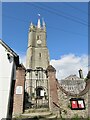
2
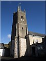
St Lawrence's Tower, Ashburton
Another view of the tower fully described at Image from within the yard.
Image: © Derek Harper
Taken: 9 Mar 2009
0.01 miles
3
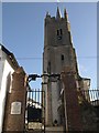
St Lawrence's Tower, Ashburton
This view of Image, the description of which carries the details, shows the red-brick gate piers with moulded pyramidal caps and overthrow lamp above the gate. http://www.imagesofengland.org.uk/Details/Default.aspx?id=376147&mode=adv
Image: © Derek Harper
Taken: 9 Mar 2009
0.01 miles
4
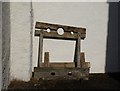
Stocks, Ashburton
These stocks stand against a wall below Image
Image: © Derek Harper
Taken: 9 Mar 2009
0.01 miles
5
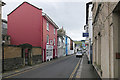
St Lawrence Lane, Ashburton
The Red Mullet fish and chip shop in St Lawrence Lane, Ashburton.
Image: © Alan Hunt
Taken: 28 Feb 2016
0.01 miles
6
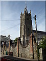
Chapel of St Lawrence, Ashburton
A sign outside the building proclaims: - A chantry given to Ashburton by Bishop Stapledon A.D. 1314. A grammar school until 1938. Lawful meeting place of the annual Courts Leet and Baron since 1593.
Image: © Chris Allen
Taken: 17 Jul 2017
0.02 miles
7
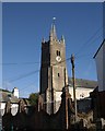
St Lawrence's Tower, Ashburton
"Although the tower is of late 15th or early 16th century date, and the nave mostly rebuilt in the 1740s, some of its fabric dates back to the late 13th century and is part of the Chantry Chapel given to the town by Bishop Stapledon in 1314. Its historic significance is therefore considerable, not least because it may have been part of a Bishop’s Palace and was converted to a Grammar School in 1593." http://www.dartmoor-npa.gov.uk/li-caaashb-04.pdf A detailed architectural description is at http://www.imagesofengland.org.uk/Details/Default.aspx?id=376146&mode=adv . Additionally listed are the gate piers and boundary wall in the foreground, probably mid-C18 - http://www.imagesofengland.org.uk/Details/Default.aspx?id=376147&mode=adv .
Image: © Derek Harper
Taken: 9 Mar 2009
0.02 miles
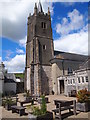
9
Ashburton - Chapel of St Lawrence
Historic chantry, grammar school and courthouse on St Lawrence Lane.
www.discoverashburton.info
Image: © Colin Smith
Taken: 27 Jul 2021
0.02 miles
10
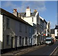
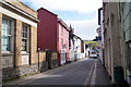
St Lawrence Lane, Ashburton
The row of cottages on the left are listed and described at http://www.imagesofengland.org.uk/Details/Default.aspx?id=376137&mode=adv . After this are the green-painted Holly House (http://www.imagesofengland.org.uk/Details/Default.aspx?id=376136&mode=adv ), the three-storey Stafford House (http://www.imagesofengland.org.uk/Details/Default.aspx?id=376135&mode=adv ) and the Post Office 9http://www.imagesofengland.org.uk/details/default.aspx?id=376134 ).
Image: © Derek Harper
Taken: 9 Mar 2009
0.02 miles