IMAGES TAKEN NEAR TO
Knights Mead, NEWTON ABBOT, TQ13 0RF
Introduction
This page details the photographs taken nearby to Knights Mead, TQ13 0RF by members of the Geograph project.
The Geograph project started in 2005 with the aim of publishing, organising and preserving representative images for every square kilometre of Great Britain, Ireland and the Isle of Man.

There are currently over 7.5m images from over14,400 individuals and you can help contribute to the project by visiting https://www.geograph.org.uk
Image Map
Images are licensed for reuse under creativecommons.org/licenses/by-sa/2.0
Notes
- Clicking on the map will re-center to the selected point.
- The higher the marker number, the further away the image location is from the centre of the postcode.
Image Listing (77 Images Found)
Images are licensed for reuse under creativecommons.org/licenses/by-sa/2.0
Image
Details
Distance
1
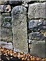
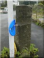
Old Bridge Marker in Chudleigh Knighton
County Bridge Marker set in a stone wall on the northwest side of the B3344 in Chudleigh Knighton, 100 metres northeast of Bunkers Bridge. Hennock parish. Inscribed C, the stone marks the extent of roadway adjoining the bridge that the County was obliged to maintain.
Milestone Society National ID: DV_HENN01br
Image: © S Vowden
Taken: 5 Dec 2020
0.03 miles
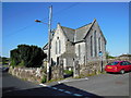
6
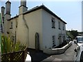
Beal Farm, Chudleigh Knighton
A former farmhouse on the main road through the village. On the side wall is a granite gatepost, and a road gives access to the recent development of Beal Farm Mews. The farmhouse porch is supported on two unusual long barley-sugar twist uprights.
Image: © David Smith
Taken: 12 Jul 2013
0.05 miles
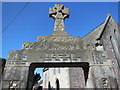
7
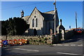
Chudleigh Knighton Church
On the right, the gateway with a cross is the war memorial for the village
Image: © David Smith
Taken: 12 Jul 2013
0.05 miles
8
Old Guide Stone by the B3344, Chudleigh Knighton, Hennock Parish
Ashburton guidestone by the B3344 (was A38), in parish of Hennock (Teignbridge District), Chudleigh Knighton, North East of St Paul's Church at fork in road, junction of Capelry and Homelea, on verge beside water hydrant.
Inscription reads:-
: TO / BOVEY / TO / CHUDLEIGH : : TO / CHUDLEIGH / TO / ASHBURTON :
Grade II listed. List Entry Number: 1097419
https://historicengland.org.uk/listing/the-list/list-entry/1097419
Surveyed
Milestone Society National ID: DV_XHEN05
Image: © Alan Rosevear
Taken: 10 Oct 2012
0.06 miles
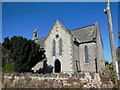
9
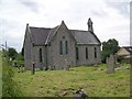
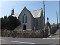
St Paul's Church, Chudleigh Knighton
The church stands in a large churchyard.
Image: © Maigheach-gheal
Taken: 17 Aug 2008
0.07 miles
10
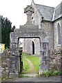
Gate, St Paul's Church, Chudleigh Knighton
The arch to the gate is the village War Memorial.
Image: © Maigheach-gheal
Taken: 17 Aug 2008
0.07 miles