1
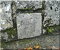
Old Bridge Marker by Clifford Street, Chudleigh parish
Bridge Marker by the UC road, in parish of Chudleigh (Teignbridge District), set in a stone wall by a sunken water hydrant on the southwest side of Clofford Street 80 metres northwest of Bridgeland Bridge, Kate Brook.
Surveyed
Milestone Society National ID: DV_CHAC01Bbr
Image: © Alan Rosevear
Taken: 8 Apr 2013
0.06 miles
2
Town Mill, Chudleigh
The backshot (pitchback) waterwheel built in 1860 by Ivor Hall of Ideford and 20' diameter by 3' 6" wide. In 1998 it was reported as turning regularly but now looks deteriorated and I doubt that it turns. The mill worked until c1940 and became a craft studio and tea rooms but is now housing and the wheel is across a gated courtyard and cannot be approached.
Image: © Chris Allen
Taken: 30 Dec 2011
0.06 miles
3
Housing in Glebelands
Modern houses in a cul-de-sac
Image: © David Smith
Taken: 13 Mar 2012
0.06 miles
4
Former Town Mill, Chudleigh
This former water mill became craft studios and tea rooms but is now accommodation. The wheel is described as backshot and is 20' x 3' 6" and in 1998 was described as often seen turning. It now looks somewhat deteriorated and I doubt it turns. The rather nice mill house with portico is nearest the photographer.
Image: © Chris Allen
Taken: 30 Dec 2011
0.07 miles
5
Modern footbridge over Kate Brook and its floodplain
A modern bridge which avoids the older bridge which has no footway to link the town centre to the housing east of the stream.
Image: © David Smith
Taken: 13 Mar 2012
0.07 miles
6
Old Bridge Marker
Bridge Marker set in the south parapet of Bridgeland Bridge, Kate Brook, on Clifford Street. Chudleigh parish.
Inscribed THIS BRIDGE / WAS REPEARD / AT THE COUN / TIES CHARGE / 1681 & 1811
Carved benchmark
The bridge is Grade II Listed, details https://historicengland.org.uk/listing/the-list/list-entry/1097098. See also http://www.flickr.com/photos/tollhouses/8192460041 and https://www.geograph.org.uk/photo/6658927.
Milestone Society National ID: DV_CHAC02br
Image: © Alan Rosevear
Taken: 17 Nov 2012
0.08 miles
7
Bridge, Kate Brook, Chudleigh
Bridge Plaque & Bench Mark over Kate Brook, Clifford Street. 54.6 m ASL. Inscription ""THIS BRIDGE WAS REPEARD AT THE COVИ TIES CHARGE 1681 & 1811" (repaired & county's)
Milestone Society National ID: DV_CHAC02br
Image: © Sheron Vowden
Taken: 30 Oct 2020
0.08 miles
8
Bridge at the foot of Clifford Street over Kate Brook
Image: © David Smith
Taken: 13 Mar 2012
0.09 miles
9
Children's playground in Chudleigh
Image: © Sarah Charlesworth
Taken: 29 Oct 2009
0.10 miles
10
Old Bridge Marker on Mount Pleasant, Chudleigh
County Bridge Marker behind two stop valve markers 80 metres northeast of Bridgeland Bridge, Kate Brook, low down in a stone wall on the northeast side of the junction of Mount Pleasant and Lears Lane. Chudleigh parish. Inscribed C to mark the extent of roadway adjoining the bridge that the County was obliged to maintain. See also https://www.geograph.org.uk/photo/6047501 and http://www.flickr.com/photos/tollhouses/8193549912
Milestone Society National ID: DV_CHAC01Abr
Image: © M Piper
Taken: 1 Jul 2023
0.11 miles


