IMAGES TAKEN NEAR TO
Chudleigh Knighton, Chudleigh, NEWTON ABBOT, TQ13 0HJ
Introduction
This page details the photographs taken nearby to TQ13 0HJ by members of the Geograph project.
The Geograph project started in 2005 with the aim of publishing, organising and preserving representative images for every square kilometre of Great Britain, Ireland and the Isle of Man.

There are currently over 7.5m images from over14,400 individuals and you can help contribute to the project by visiting https://www.geograph.org.uk
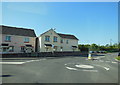
Image Map
Images are licensed for reuse under creativecommons.org/licenses/by-sa/2.0
Notes
- Clicking on the map will re-center to the selected point.
- The higher the marker number, the further away the image location is from the centre of the postcode.
Image Listing (67 Images Found)
Images are licensed for reuse under creativecommons.org/licenses/by-sa/2.0
Image
Details
Distance
1

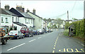
Cottages at Chudleigh Knighton
At the southwestern edge of the village, these cottages seem likely to have been built for workers in the nearby clay pits. The road, now the B3344, was formerly the main road to Plymouth.
Image: © Derek Harper
Taken: 17 Feb 2009
0.04 miles
2
The B3344 at Knights Mead, Chudleigh Knighton
Image: © Ian S
Taken: 26 May 2013
0.06 miles
4
Plymouth Road and a footpath cross a brook
A number of brooks rise near Dunley, join and flow south to the river Teign south of Chudleigh Knighton, bridged by the Plymouth Road here. The parapet is of the grey Devonian limestone. The turning to the left is the recent Hadfield Court.
Image: © Robin Stott
Taken: 24 Aug 2011
0.07 miles
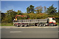
5
A38 past Chudleigh Knighton
Seen from Piper House Lane, near the north end of Hennock bridleway no.22. (My thanks to other contributors for the name of the bridleway)
Image: © Robin Stott
Taken: 3 Jan 2010
0.08 miles
6
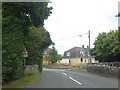
Chudleigh Knighton approach
New and old housing on the approach to Chudleigh Knighton, taken from the B3344. The bus shelter on the right is typical of those to be found on the rural routes in the area, assuming there's one at all!!
Image: © Mike Crowe
Taken: 23 May 2005
0.09 miles
7
Bridge on west edge of Chudleigh Knighton
Seen from the west; the reverse view is at Image
Image: © David Smith
Taken: 15 Jul 2020
0.11 miles
8
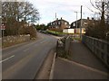
Bridge in Chudleigh Knighton
The B3344 crosses a small tributary of the Teign as it enters the village.
Image: © Derek Harper
Taken: 17 Feb 2009
0.11 miles
9
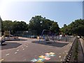
Children's playground, Chudleigh Knighton
Image: © David Smith
Taken: 12 Jul 2013
0.12 miles
10
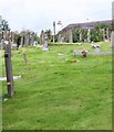
Churchyard, St Paul's Church, Chudleigh Knighton
The other side of the churchyard is the thatched roof of the Claycutters Arms.
Image: © Maigheach-gheal
Taken: 17 Aug 2008
0.12 miles