IMAGES TAKEN NEAR TO
Carders Walk, NEWTON ABBOT, TQ13 0FT
Introduction
This page details the photographs taken nearby to Carders Walk, TQ13 0FT by members of the Geograph project.
The Geograph project started in 2005 with the aim of publishing, organising and preserving representative images for every square kilometre of Great Britain, Ireland and the Isle of Man.

There are currently over 7.5m images from over14,400 individuals and you can help contribute to the project by visiting https://www.geograph.org.uk
Image Map
Images are licensed for reuse under creativecommons.org/licenses/by-sa/2.0
Notes
- Clicking on the map will re-center to the selected point.
- The higher the marker number, the further away the image location is from the centre of the postcode.
Image Listing (27 Images Found)
Images are licensed for reuse under creativecommons.org/licenses/by-sa/2.0
Image
Details
Distance
1
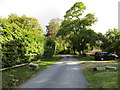
Orange Way in Devon and Torbay (155)
The B3344 is just ahead.
Image: © Shazz
Taken: 20 Oct 2011
0.04 miles
2
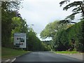
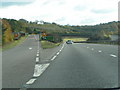
B3344 approaching A38 from Chudleigh
The name of the road junction is recorded on the sign, and recalls the non-existent railway station. The station was used by passengers from 1882 to 1958, with goods use continuing until 1967.
Image: © David Smith
Taken: 8 Sep 2011
0.09 miles
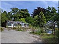
3
Entrance to the Rock Nursery, Chudleigh
Looking across the B3344 (the former A38). Associated with the nursery are the Rock Gardens, "set in the picturesque setting of the old Palace Quarry" http://www.therockgardens.co.uk/ .
Image: © Derek Harper
Taken: 12 Dec 2010
0.13 miles
4
Buildings at Chudleigh Rocks looking worse for wear
Image: © Rob Purvis
Taken: 12 Aug 2020
0.14 miles
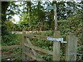
6
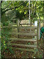
Orange Way in Devon and Torbay (154)
There's a kissing gate on the way up to the road.
Image: © Shazz
Taken: 20 Oct 2011
0.15 miles
7
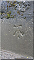
Benchmark Chudleigh
WALL SE SIDE RD NE SIDE HO BRYN (in OS database) - 61.1 m ASL - Station Hill. Near the Garden Centre/Nursery
Image: © Sheron Vowden
Taken: 30 Oct 2020
0.15 miles
8
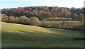
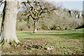
Kate Brook valley
A view from Chudleigh Footpath 14 across Lawell Park, with afternoon sunshine highlighting a sloping terrace on this side of the valley, and a line of oaks following a ride across the park on the other side, with Lawelldown Wood beyond.
Image: © Derek Harper
Taken: 12 Dec 2010
0.19 miles
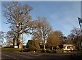
9
Junction for Chudleigh on the A38 west-bound
Image: © Rob Purvis
Taken: 8 Nov 2009
0.19 miles
10
Chudleigh Rocks from Lawell Park
The limestone crags seen across the Kate Brook valley from the grounds of a country house - looking north-east.
Image: © Derek Harper
Taken: Unknown
0.20 miles