IMAGES TAKEN NEAR TO
Kingsteignton Road, NEWTON ABBOT, TQ13 0AJ
Introduction
This page details the photographs taken nearby to Kingsteignton Road, TQ13 0AJ by members of the Geograph project.
The Geograph project started in 2005 with the aim of publishing, organising and preserving representative images for every square kilometre of Great Britain, Ireland and the Isle of Man.

There are currently over 7.5m images from over14,400 individuals and you can help contribute to the project by visiting https://www.geograph.org.uk
Image Map
Images are licensed for reuse under creativecommons.org/licenses/by-sa/2.0
Notes
- Clicking on the map will re-center to the selected point.
- The higher the marker number, the further away the image location is from the centre of the postcode.
Image Listing (43 Images Found)
Images are licensed for reuse under creativecommons.org/licenses/by-sa/2.0
Image
Details
Distance
1
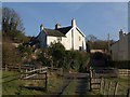
Bellamarsh Barton
The place is recorded in 1242 as Beldemerse; "a large mill was formerly associated with the house and was the scene of bread riots during the Napoleonic wars. Thomas Campion, a blacksmith from Ilsington was deemed to have been the leader of the riot and his execution, said to have taken place at Bellamarsh in 1795 was the last public hanging in the country" http://www.imagesofengland.org.uk/details/default.aspx?id=85358 , which gives an extensive description of the architecture of this C15 or even older building.
Image: © Derek Harper
Taken: 12 Dec 2010
0.03 miles
2
Track to Bellamarsh Barton
At this point Kingsteignton Footpath 6 leaves the track which it has followed from Gappah, and skirts the farm which can be glimpsed below. Across the floodplain is the A38 crossing the River Teign, with Haytor on the skyline.
Image: © Derek Harper
Taken: 17 Feb 2009
0.03 miles
3
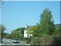
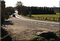
Bellamarsh Barton
The B3193 now curves to the left to cross the A38. Formerly the road curved to the right, along a track just beyond the red car.
Image: © David Smith
Taken: 21 Apr 2011
0.05 miles
4
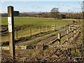
Footpath from Bellamarsh
Kingsteignton Footpath 6 leaves the B3193 at Bellamarsh Barton to cross the floodplain of the River Teign. The path turns left to run between the oak and the A38, using the river bridge to cross the dual carriageway, which follows the line of an old railway. Housing at Chudleigh Knighton can be seen beyond.
Image: © Derek Harper
Taken: 17 Feb 2009
0.06 miles
5
B3193 at Bellamarsh Barton
The B road is heading along the Teign valley towards Rixeypark Corner, having just crossed the A38 and the river. Seen from the point at which Kingsteignton Footpath 6 crosses it.
Image: © Derek Harper
Taken: 17 Feb 2009
0.09 miles
6
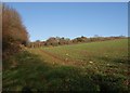
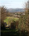
Field near Bellamarsh Barton
From Kingsteignton Footpath 6 at the top of a short but steep flight of steps up a wooded bank from a track to Bellamarsh Copse, part of which can be seen across two fields.
Image: © Derek Harper
Taken: 12 Dec 2010
0.11 miles
7
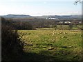
Field near Sandslade Copse
Part of this view can be seen on the left of Image The field drops towards the Bovey basin. The clay shed on the right is in Image Beyond is the industrial estate at Heathfield.
Image: © Derek Harper
Taken: 17 Feb 2009
0.12 miles
8
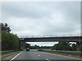
B3193 bridge over A38
The bridge also crosses the broad valley of the River Teign
Image: © David Smith
Taken: 8 Sep 2011
0.13 miles

10
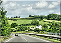
A38, Bellamarsh Barton
Heading north.
Image: © Pierre Terre
Taken: 20 Jun 2009
0.14 miles