
IMAGES TAKEN NEAR TO
Orchard Close, NEWTON ABBOT, TQ12 6EA
Introduction
This page details the photographs taken nearby to Orchard Close, TQ12 6EA by members of the Geograph project.
The Geograph project started in 2005 with the aim of publishing, organising and preserving representative images for every square kilometre of Great Britain, Ireland and the Isle of Man.

There are currently over 7.5m images from over14,400 individuals and you can help contribute to the project by visiting https://www.geograph.org.uk
Image Map
Images are licensed for reuse under creativecommons.org/licenses/by-sa/2.0
Notes
- Clicking on the map will re-center to the selected point.
- The higher the marker number, the further away the image location is from the centre of the postcode.
Image Listing (66 Images Found)
Images are licensed for reuse under creativecommons.org/licenses/by-sa/2.0
Image
Details
Distance
1
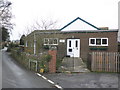
Village Hall, Woodland Road, Denbury
Image: © Roger Cornfoot
Taken: 11 Dec 2009
0.07 miles
2
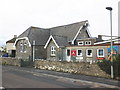
Primary School, West Street, Denbury
Image: © Roger Cornfoot
Taken: 11 Dec 2009
0.08 miles
4
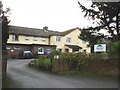
The Old Rectory (Chesten House) Denbury
The 'Old Rectory' is the house closest to the camera and in the centre of the picture, only half of it is within OS8168.Image
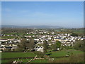
The view shows Denbury village and on the skyline can be seen three Teign estuary towns. These are from left to right Kingsteignton (the town on the Teign owned by the king), Bishopsteignton and on the far right at the mouth of the estuary is Teignmouth.
The view is taken from the public access track up to the Denbury iron age hill fort.
Image: © Colin Vosper
Taken: 6 Apr 2011
0.09 miles
5
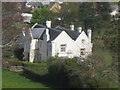
The Old Rectory (Chesten House) Denbury
A telephoto view of this old house on the edge of the village. This house like some of the principal houses in the old village used to have its water sourced from a spring that comes from water collected in the water-bearing limestone rock of the Denbury hill on which the photographer is standing.Image
Image: © Colin Vosper
Taken: 10 Apr 2011
0.09 miles
7
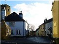
The centre of the village of Denbury
Image: © Ruth Sharville
Taken: 30 Dec 2013
0.13 miles
9
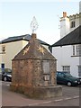
Denbury Cistern
Another view of Image decorated for Christmas. Described as a "Water Conduit head, it may originally have been the village lock-up, converted to use as a water cistern in 1771 (the date it bears on the finial surmounting the pyramidal roof). The cistern has become the village's war memorial. The water supply was disconnected in 1962 http://www.imagesofengland.org.uk/Details/Default.aspx?id=431854&mode=adv and from notice attached; there are more details at http://www.lhi.org.uk/docs/denbury_cistern2.pdf , which includes a celebration of its significance in village life, and an account of water supply to the community. The light feature on top dates from the 2000 millennium.
Image: © Derek Harper
Taken: 18 Dec 2009
0.14 miles
10
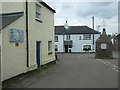
Crossroads at the centre of Denbury
On the wall at the left is a mosaic made by the local Brownies to mark the centenary of Girl Guides in 2010. In the centre of the street is the Denbury Cistern. It supplied water to the village from a spring on Denbury Down until the 20th century.
Image: © David Smith
Taken: 3 May 2011
0.15 miles