IMAGES TAKEN NEAR TO
Torbryan, NEWTON ABBOT, TQ12 5UR
Introduction
This page details the photographs taken nearby to TQ12 5UR by members of the Geograph project.
The Geograph project started in 2005 with the aim of publishing, organising and preserving representative images for every square kilometre of Great Britain, Ireland and the Isle of Man.

There are currently over 7.5m images from over14,400 individuals and you can help contribute to the project by visiting https://www.geograph.org.uk
Image Map
Images are licensed for reuse under creativecommons.org/licenses/by-sa/2.0
Notes
- Clicking on the map will re-center to the selected point.
- The higher the marker number, the further away the image location is from the centre of the postcode.
Image Listing (141 Images Found)
Images are licensed for reuse under creativecommons.org/licenses/by-sa/2.0
Image
Details
Distance
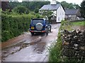
1
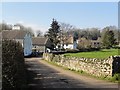
Houses in Torbryan
Looking along the only road in the village of Torbryan.
Image: © Tony Atkin
Taken: 26 Feb 2012
0.05 miles
2
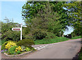
Torbryan - with well stocked traffic island
There is a footpath sign to the right of the road sign.
Image: © paul dickson
Taken: 10 May 2008
0.06 miles
3

Torbryan and Broadway Farm
Looking south from the road to Denbury.
Image: © Guy Wareham
Taken: 16 Sep 2008
0.06 miles
4
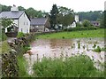
Slight flood at Torbryan
The stream at Torbryan should, as far as I know, flow in a channel behind the camera. After a prolonged and torrential downpour, it has dramatically invaded this neighbouring field. You can see it gurgling into a culvert to join a small watercourse that runs down beside the road from the church. The flooded lane on the left is shown in Image
Image: © Derek Harper
Taken: 30 May 2008
0.07 miles
5

Torbryan
A summer evening at Torbryan, the same scene as Image a few weeks earlier. The field is now dry and the watercourse has returned to its normal channel.
Image: © Derek Harper
Taken: 22 Jul 2008
0.07 miles
7
Slight flood at Torbryan
A car splashes through the flooded lane where the stream at Torbryan has burst its banks during very heavy rain.
Image: © Derek Harper
Taken: 30 May 2008
0.08 miles
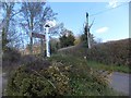
8
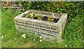
Trough, Torbryan
I'd guess that Captain Quintanilha could be the one listed in Kelly's 1893 as Henry, Hon. Sec. of the RSPCA in Courtenay Park, Newton Abbot, an antivivisectionist and therefore quite likely to be inclined to provide an animal drinking trough. This is beside the junction shown in Image
Image: © Derek Harper
Taken: 9 May 2021
0.08 miles
9
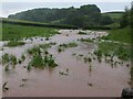
Flooded field, Torbryan
Looking up the field shown in Image, occupied by the stream after it burst its banks. Up the valley is Clennonpark Wood, in SX8267.
Image: © Derek Harper
Taken: 30 May 2008
0.09 miles
10
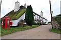
The Church House Inn, Torbryan
To the southeast of Torbryan church (Image) lies the 13th century freehouse, The Church House Inn. The Building, erected by stonemasons in 1340, has over the centuries incorporated many features from different periods of English history. This unique, part-thatched Country Inn is a "Grade 2" listed building.
Image: © Paul Hutchinson
Taken: 24 Dec 2008
0.09 miles