IMAGES TAKEN NEAR TO
Queensway, NEWTON ABBOT, TQ12 4BH
Introduction
This page details the photographs taken nearby to Queensway, TQ12 4BH by members of the Geograph project.
The Geograph project started in 2005 with the aim of publishing, organising and preserving representative images for every square kilometre of Great Britain, Ireland and the Isle of Man.

There are currently over 7.5m images from over14,400 individuals and you can help contribute to the project by visiting https://www.geograph.org.uk
Image Map
Images are licensed for reuse under creativecommons.org/licenses/by-sa/2.0
Notes
- Clicking on the map will re-center to the selected point.
- The higher the marker number, the further away the image location is from the centre of the postcode.
Image Listing (74 Images Found)
Images are licensed for reuse under creativecommons.org/licenses/by-sa/2.0
Image
Details
Distance
1
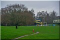
Newton Abbot : Buckland Playing Fields
A large open space.
Image: © Lewis Clarke
Taken: 31 Dec 2021
0.10 miles
2
Newton Abbot : Buckland Playing Fields
Looking across the playing field.
Image: © Lewis Clarke
Taken: 31 Dec 2021
0.13 miles
4
Newton Abbot : Buckland Playing Fields
Looking across the park.
Image: © Lewis Clarke
Taken: 31 Dec 2021
0.16 miles
6
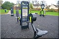
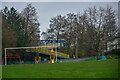
Newton Abbot : Buckland Playing Fields
Exercise equipment in the park provides a place to get healthy.
Image: © Lewis Clarke
Taken: 31 Dec 2021
0.16 miles
7

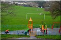
Newton Abbot : Buckland Playing Fields
Exercise equipment in the park.
Image: © Lewis Clarke
Taken: 31 Dec 2021
0.17 miles
8
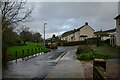
Newton Abbot : Penn Inn Close
A small road.
Image: © Lewis Clarke
Taken: 31 Dec 2021
0.17 miles
9
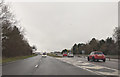
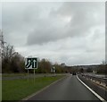
Bad Homburg Way
This is Image looking in the other direction from the same footbridge. The A380 climbs a little and then curves left to drop to the Penn Inn roundabout. This unnecessary hill implies that the designers planned for a flyover to carry the main road above the junction, and the descent would have been merely the slip road to the roundabout. Nearly thirty years later, this remains the end of the dual carriageway.
Image: © Derek Harper
Taken: 5 Jun 2008
0.17 miles
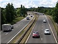
10
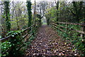
Footpath by the Aller Brook
This long and thin strip of land between the A380 Besigheim Way on the right and the Aller Brook down the bank on the left is part of the Aller Brook Nature Reserve.
Image: © jeff collins
Taken: 29 Oct 2014
0.18 miles