IMAGES TAKEN NEAR TO
Tarrs Avenue, NEWTON ABBOT, TQ12 3BX
Introduction
This page details the photographs taken nearby to Tarrs Avenue, TQ12 3BX by members of the Geograph project.
The Geograph project started in 2005 with the aim of publishing, organising and preserving representative images for every square kilometre of Great Britain, Ireland and the Isle of Man.

There are currently over 7.5m images from over14,400 individuals and you can help contribute to the project by visiting https://www.geograph.org.uk
Image Map
Images are licensed for reuse under creativecommons.org/licenses/by-sa/2.0
Notes
- Clicking on the map will re-center to the selected point.
- The higher the marker number, the further away the image location is from the centre of the postcode.
Image Listing (62 Images Found)
Images are licensed for reuse under creativecommons.org/licenses/by-sa/2.0
Image
Details
Distance
1
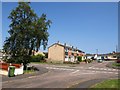
Roseland Square, Kingsteignton
A terrace of five seen across Tarr's Avenue from Primrose Close.
Image: © Derek Harper
Taken: 23 Jun 2009
0.05 miles
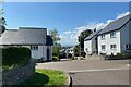
2
Houses on Vicarage Hill, Kingsteignton
A terrace of four by the roundabout junction with Greenhill Way.
Image: © Derek Harper
Taken: 28 Sep 2019
0.07 miles
3
Houses on Vicarage Hill, Kingsteignton
To the west of those shown in Image
Image: © Derek Harper
Taken: 28 Sep 2019
0.07 miles
4
Fore Street, Kingsteignton
The first two houses on the left are originally C15: "The original circa late C15 house was of 3-room plan, the 2 right-hand rooms now occupied by No 51 and the narrow left-hand room is part of No 49. It was originally open to the roof throughout. In about C16 a floor was inserted over the right hand room jettied into the still open hall (central room). Later, probably in C17 the left hand room and hall were floored when a rear lateral stack was built to heat the hall." http://www.imagesofengland.org.uk/Details/Default.aspx?id=85419&mode=adv
Image: © Derek Harper
Taken: 23 Jun 2009
0.09 miles
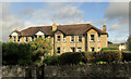
5
House with a central chimney, Golvers Hill Road, Kingsteignton
The house looks old: the massive tall central chimney is a clue. It's possible that this form reduced the risk of sparks setting light to a thatched roof.
Image: © Robin Stott
Taken: 25 Apr 2022
0.09 miles
6
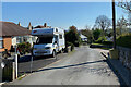
Lower end of Golvers Hill Road, Kingsteignton
On the left, modest bungalows perhaps date from the early years of Kingsteignton's expansion. Who knows if the property is the home of a local resident, or a second home, or a holiday let. A late twentieth-century trend is illustrated: a front garden has become a parking space. On the right is the entry to Leat Close, a much more recent development. The house down the hill looks old: the massive tall central chimney is a clue. It's possible that this form reduced the risk of sparks setting light to a thatched roof.
Image: © Robin Stott
Taken: 25 Apr 2022
0.10 miles
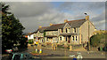
7
New Houses on Golvers Hill Road
This is marked on the map as a small area of woodland but it's woodland no longer.
Image: © Tony Atkin
Taken: 18 Sep 2008
0.12 miles
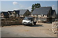
8
Leat Close, Kingsteignton
Some maps show a mill leat running down the hill, parallel to Golvers Hill Road. It would appear to be the diversion of a stream originating on Little Haldon that eventually joins the River Teign below the village.
Image: © Robin Stott
Taken: 25 Apr 2022
0.12 miles
9
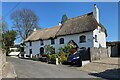
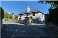
Two thatched cottages, Golvers Hill Road, Kingsteignton
Last seen in 2015: Image
Image: © Robin Stott
Taken: 25 Apr 2022
0.12 miles
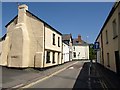
10
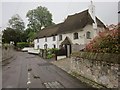
Thatched cottages, Kingsteignton
Both these cottages, on Golvers Hill Road and seen from its junction with Crossley Moor Road are listed; the nearer is described at http://list.historicengland.org.uk/resultsingle.aspx?uid=1165477&searchtype=mapsearch, the further at http://list.historicengland.org.uk/resultsingle.aspx?uid=1097055&searchtype=mapsearch . It's raining a little and will soon rain quite a lot.
Image: © Derek Harper
Taken: 12 Jun 2015
0.12 miles