IMAGES TAKEN NEAR TO
Orchard Road, TORQUAY, TQ1 1JE
Introduction
This page details the photographs taken nearby to Orchard Road, TQ1 1JE by members of the Geograph project.
The Geograph project started in 2005 with the aim of publishing, organising and preserving representative images for every square kilometre of Great Britain, Ireland and the Isle of Man.

There are currently over 7.5m images from over14,400 individuals and you can help contribute to the project by visiting https://www.geograph.org.uk
Image Map
Images are licensed for reuse under creativecommons.org/licenses/by-sa/2.0
Notes
- Clicking on the map will re-center to the selected point.
- The higher the marker number, the further away the image location is from the centre of the postcode.
Image Listing (148 Images Found)
Images are licensed for reuse under creativecommons.org/licenses/by-sa/2.0
Image
Details
Distance
1
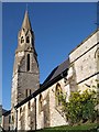
Christ Church, Ellacombe
Built of local limestone in 1868, "with a SW tower-porch which turns octagonal and ends with a spire" (Cherry & Pevsner). There is an account of the history at http://www.christchurch-ellacombe.org.uk/history.htm , which describes the architecture as "early Gothic Revival", and mentions that the warmer-coloured dressings to the windows and spire are of Bath stone. The church is prominently-placed above the junction of Ellacombe Church Road and Image
Image: © Derek Harper
Taken: 26 Jan 2008
0.03 miles
2
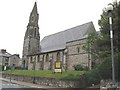
Ellacombe, Torquay - Christ Church
Built as part of increase in parishes to cope with urban growth, Ellacombe being formed out of the existing Parish of Upton. This church was consecrated in 1868.
Image: © Ken Newell
Taken: 17 May 2008
0.04 miles
3
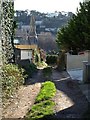
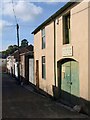
Back lane off Dunmere Road, Torquay
This track gives access to the rear of dwellings on Dunmere Road and Ellacombe Church Road. It bends left to run above the rear of Christ Church, with its short octagonal tower and spire.
Image: © Derek Harper
Taken: 26 Jan 2008
0.04 miles
4
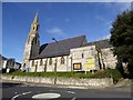
Christ Church, Ellacombe
A church built in the 1860s to serve the growing suburbs of Torquay. Another sign of the growth at that time is in the Victorian post box in the wall a short way from here Image]
Image: © David Smith
Taken: 27 Jan 2015
0.04 miles
5
Hoxton Road, Ellacombe
This northern stretch of the road slopes gently from its junction with Ellacombe Church Road, opposite the church (behind the camera). From the junction on the left of the photo, 120 metres away, Hoxton Road winds very steeply upwards towards the Warberries.
Image: © Derek Harper
Taken: 26 Jan 2008
0.05 miles
6
Hoxton Road, Ellacombe
Houses converted into flats.
Image: © Derek Harper
Taken: 15 May 2018
0.05 miles
7
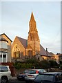
Ellacombe Church
The evening sun illuminates Christ Church, the parish church of Ellacombe, Torquay.
Image: © Paul Hutchinson
Taken: 24 Nov 2008
0.05 miles
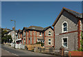
8
Alexandra Lane, Ellacombe
A row of small businesses in this back lane between Alexandra Road and Princes Road.
Image: © Derek Harper
Taken: 10 Oct 2008
0.06 miles
9
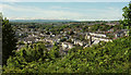
View over Ellacombe
From close to the end of Higher Warberry Road where it meets the track extension of Rosehill Road. Right of centre is Christ Church http://www.geograph.org.uk/search.php?i=83959709 . Dartmoor is on the horizon.
Image: © Derek Harper
Taken: 15 May 2018
0.06 miles
10
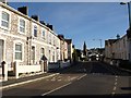
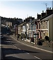
Ellacombe Church Road,Torquay
Terraced housing along the road as it curves towards Image To the right is the junction with Mount Pleasant Road.
Image: © Derek Harper
Taken: 26 Jan 2008
0.06 miles