IMAGES TAKEN NEAR TO
Marl Park, BUCKFASTLEIGH, TQ11 0HZ
Introduction
This page details the photographs taken nearby to Marl Park, TQ11 0HZ by members of the Geograph project.
The Geograph project started in 2005 with the aim of publishing, organising and preserving representative images for every square kilometre of Great Britain, Ireland and the Isle of Man.

There are currently over 7.5m images from over14,400 individuals and you can help contribute to the project by visiting https://www.geograph.org.uk
Image Map
Images are licensed for reuse under creativecommons.org/licenses/by-sa/2.0
Notes
- Clicking on the map will re-center to the selected point.
- The higher the marker number, the further away the image location is from the centre of the postcode.
Image Listing (73 Images Found)
Images are licensed for reuse under creativecommons.org/licenses/by-sa/2.0
Image
Details
Distance
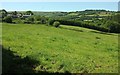
1
Scorriton
A view from the same spot as Image], looking more to the left across the Holy Brook valley, with the wooded Mardle valley behind leading up towards Pupers Hill.
Image: © Derek Harper
Taken: 18 Jun 2017
0.02 miles
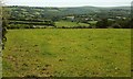
2
Fields at Scorriton
Looking to the left compared to Image, with the Holy Brook valley on the right and Scorriton Farm on the left. Holne Moor rises in the distance.
Image: © Derek Harper
Taken: 18 Jun 2017
0.02 miles
3
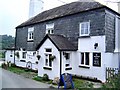
Scorriton - Dartmoor
The Tradesman's Arms - a quiet local pub. The pub is probably over 200 years old and at one time used to relieve thirsty miners who used to work up on the moor some miles away.
Image: © Richard Knights
Taken: Unknown
0.02 miles
4
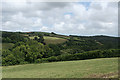
West Buckfastleigh: at Scoriton
Looking down the valley of the Holy Brook from the car park of The Tradesman's Arms. Hembury Woods are on the skyline, right; part of the National Trust estate
Image: © Martin Bodman
Taken: 15 Jul 2010
0.03 miles
5
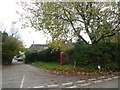
Road to Holne from Scorriton
On the right is a small marker for the Two Moors Way; the phone box is empty
Image: © David Smith
Taken: 23 Oct 2018
0.05 miles
6
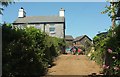
Scoriton Farm
Taking the spelling from the board shown in Image], which shows the other side of the farmhouse. This view is from a lane which carries the Two Moors Way and the Dartmoor Way down to Langaford Bridge.
Image: © Derek Harper
Taken: 18 Jun 2017
0.06 miles
7
The Tradesmans Arms, Scorriton
A traditional style pub with a lively atmosphere and the centre of village activities.
Image: © Maigheach-gheal
Taken: 13 May 2009
0.06 miles
8
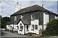
West Buckfastleigh: The Tradesman's Arms
The pub, closed for two years, has had a complete make-over internally and re-opened in January 2009. There are good views over Scoriton Combe from the dining area
Image: © Martin Bodman
Taken: 15 Jul 2010
0.06 miles
9
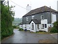
Village scene, Scorriton
Most of the things a village community needs. The telephone box is opposite.
Image: © Maigheach-gheal
Taken: 13 May 2009
0.06 miles
10
Scoriton Farm
As it is spelt on the sign on the wall. The village usually has two "r"s.
Image: © Derek Harper
Taken: 18 Jun 2017
0.06 miles