IMAGES TAKEN NEAR TO
Avonwick, SOUTH BRENT, TQ10 9LX
Introduction
This page details the photographs taken nearby to TQ10 9LX by members of the Geograph project.
The Geograph project started in 2005 with the aim of publishing, organising and preserving representative images for every square kilometre of Great Britain, Ireland and the Isle of Man.

There are currently over 7.5m images from over14,400 individuals and you can help contribute to the project by visiting https://www.geograph.org.uk
Image Map
Images are licensed for reuse under creativecommons.org/licenses/by-sa/2.0
Notes
- Clicking on the map will re-center to the selected point.
- The higher the marker number, the further away the image location is from the centre of the postcode.
Image Listing (64 Images Found)
Images are licensed for reuse under creativecommons.org/licenses/by-sa/2.0
Image
Details
Distance
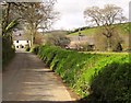
1
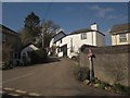
Village street, Avonwick
A different angle on the scene in , with the lane, which eventually leads to Sign of the Owl Cross, climbing steeply past cottages. The roadsign on the right warns of the crossroads some 30 metres down the hill.
Image: © Derek Harper
Taken: 18 Feb 2013
0.01 miles
2
Junction in Avonwick
The lane to Cutwellwalls Farm climbs away from the road to Kitterford Cross, in the centre of the village. On the left is Bank House http://list.english-heritage.org.uk/resultsingle.aspx?uid=1108203&searchtype=mapsearch , a pair of attached cottages the left one of which is a shop and the former post office.
Image: © Derek Harper
Taken: 18 Feb 2013
0.02 miles
3
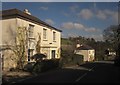
Village street, Avonwick
From the same spot as Image], looking to the right down the "30 metres" to the crossroads near the church (Image), visible right of centre. On the left is Hollymount House, which, with the two cottages at its rear, is listed http://list.english-heritage.org.uk/resultsingle.aspx?uid=1325034&searchtype=mapsearch . At the foot of the hill, across the junction with the B3212, is the Avon Inn.
Image: © Derek Harper
Taken: 18 Feb 2013
0.04 miles
4
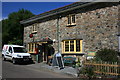
Avonwick Post Office and Village Stores
Sadly, since the picture was taken, Royal Mail have closed the Post Office, one of many such dismal actions, but the shop continues to trade.
Image: © Adrian Platt
Taken: 24 Jul 2008
0.06 miles
5
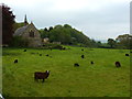
Church and a field, Avonwick, near South Brent
Image: © Ruth Sharville
Taken: 20 May 2012
0.06 miles
6
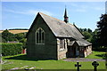
St James Church, Avonwick
St James was consecrated in 1878. It was built by the Cornish-Bowden family of Black Hall in Avonwick. The family were very prominent in local affairs and believed a church was needed as the nearest was some 2 miles away. It is known as a "proprietary chapel" as it is still maintained by the family, and as such is one of only a handful left in England. See http://www.geograph.org.uk/photo/1067233 and http://www.geograph.org.uk/photo/1067260 .
Image: © Adrian Platt
Taken: 24 Jul 2008
0.06 miles
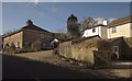
7
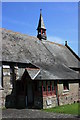
St James Church, Avonwick
The porch and spire of this proprietary chapel Image
Image: © Adrian Platt
Taken: 24 Jul 2008
0.07 miles
8
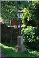
St James Church, Avonwick
An elegant and well maintained Victorian lantern in the churchyard, commemorating Queen Victoria's Jubilee in 1887. See Image and Image
Image: © Adrian Platt
Taken: 24 Jul 2008
0.07 miles
9
Approaching Avonwick
The road from North Huish runs alongside a tennis club and open field on the right; housing is behind the trees on the left. Ahead, right of centre, is Image
Image: © Derek Harper
Taken: 19 Apr 2012
0.07 miles
10
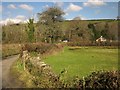
Lane, Avonwick
The back lane bends to cross the B3212.
Image: © Derek Harper
Taken: 18 Feb 2013
0.07 miles