IMAGES TAKEN NEAR TO
Parrock Lane, HARTFIELD, TN7 4AT
Introduction
This page details the photographs taken nearby to Parrock Lane, TN7 4AT by members of the Geograph project.
The Geograph project started in 2005 with the aim of publishing, organising and preserving representative images for every square kilometre of Great Britain, Ireland and the Isle of Man.

There are currently over 7.5m images from over14,400 individuals and you can help contribute to the project by visiting https://www.geograph.org.uk
Image Map
Images are licensed for reuse under creativecommons.org/licenses/by-sa/2.0
Notes
- Clicking on the map will re-center to the selected point.
- The higher the marker number, the further away the image location is from the centre of the postcode.
Image Listing (30 Images Found)
Images are licensed for reuse under creativecommons.org/licenses/by-sa/2.0
Image
Details
Distance
1
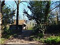
Keepers Studio, Parrock Lane, Upper Parrock
Former artist's studio now rented out as an Airbnb.
Image: © Simon Carey
Taken: 17 Apr 2021
0.01 miles
2
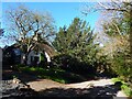
Parrock Brook, Parrock Lane, Upper Parrock
Cottage on the southern side of the lane that was built in the 18th century.
Image: © Simon Carey
Taken: 17 Apr 2021
0.02 miles
3
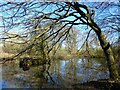
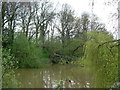
Pond, Parrock Lane
Adjacent to Image but not marked on Hartfield's 1842 tithe map though does appear on the 1874 OS map.
Image: © Simon Carey
Taken: 17 Apr 2021
0.09 miles
4
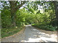
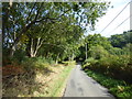
Parrock Lane
The track on the left leads to a sewage works but also is followed by a footpath which reaches Forest Way.
Image: © Marathon
Taken: 20 Sep 2020
0.09 miles
5
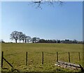
Egg Pen Field
The name of the field according to Hartfield's 1842 tithe map bounded by Parrock Lane to the north.
Image: © Simon Carey
Taken: 26 Mar 2022
0.10 miles
6
A Pond in Parrock Lane, Upper Hartfield
A pretty pond by the roadside.
Image: © Jean Barrow
Taken: 29 Apr 2006
0.10 miles
7
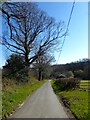
Parrock Lane
A little way ahead, a track on the left leads to a sewage works but also is followed by a footpath which reaches Forest Way.
Image: © Marathon
Taken: 20 Sep 2020
0.11 miles
8
Parrock Lane
A meandering country lane that leaves the B2110 at Qualbrook and rejoins it at Upper Hartfield.
Image: © Simon Carey
Taken: 17 Apr 2021
0.13 miles
9
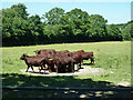
Cattle at a water trough
Several bullocks and one cow.
Image: © Robin Webster
Taken: 3 Jul 2014
0.13 miles
10
Upper Pond Mead
The name of the field according to Hartfield's 1842 tithe map located to the south of Parrock Lane.
Image: © Simon Carey
Taken: 17 Apr 2021
0.13 miles