IMAGES TAKEN NEAR TO
Motts Down, TUNBRIDGE WELLS, TN3 9PB
Introduction
This page details the photographs taken nearby to Motts Down, TN3 9PB by members of the Geograph project.
The Geograph project started in 2005 with the aim of publishing, organising and preserving representative images for every square kilometre of Great Britain, Ireland and the Isle of Man.

There are currently over 7.5m images from over14,400 individuals and you can help contribute to the project by visiting https://www.geograph.org.uk
Image Map
Images are licensed for reuse under creativecommons.org/licenses/by-sa/2.0
Notes
- Clicking on the map will re-center to the selected point.
- The higher the marker number, the further away the image location is from the centre of the postcode.
Image Listing (52 Images Found)
Images are licensed for reuse under creativecommons.org/licenses/by-sa/2.0
Image
Details
Distance
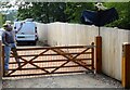
1
Motts Down Cottages, Motts Down
A pair of semi-detached cottages built in the 1950s.
Image: © Simon Carey
Taken: 4 Aug 2021
0.01 miles
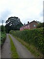
2
The Cottage, Motts Down
The single cottage was built around the 1950s and was called Motts Down Cottage on the 1970 OS map. Probably changed due to nearby Motts Down Cottages that would confuse too many postmen and other traders.
Image: © Simon Carey
Taken: 4 Aug 2021
0.03 miles
3
Scarecrow and Crow, Motts Down
Image: © Simon Carey
Taken: 29 Aug 2021
0.04 miles
4
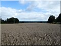
Barn Field
The name of the field according to Withyham's 1842 tithe map located to the west of Motts Down Cottages.
Image: © Simon Carey
Taken: 29 Aug 2021
0.04 miles
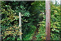
5
Cooks Field
The name of the field according to Withyham's 1842 tithe map bounded by Motts down to the west, the public footpath to Motts Mill to the south, and Motts Mill to the east.
Image: © Simon Carey
Taken: 4 Aug 2021
0.09 miles
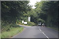
6
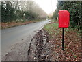
Post box near Cherry Gardens Farm
This is the B2188.
Image: © Marathon
Taken: 3 Jan 2021
0.15 miles
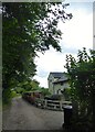
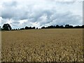
7
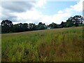
Arable Field
The name of the field according to Withyham's 1842 tithe map bounded by the lane called Motts Mill on its south and eastern side. The house in the distance is Jockeys.
Image: © Simon Carey
Taken: 29 Aug 2021
0.15 miles
9
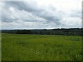
Middle Field/Upper Seven Acres
The name of the fields according to Withyham's 1842 tithe map that have been merged to form a larger unit. Middle Field is in the foreground adjacent to the public footpath to Cherry Gardens Hill, the B2188, whilst Upper Seven Acres is to the south. Both are bounded to the east by Motts Down.
Image: © Simon Carey
Taken: 4 Aug 2021
0.15 miles