IMAGES TAKEN NEAR TO
Bexhill Road, ST. LEONARDS-ON-SEA, TN38 8BL
Introduction
This page details the photographs taken nearby to Bexhill Road, TN38 8BL by members of the Geograph project.
The Geograph project started in 2005 with the aim of publishing, organising and preserving representative images for every square kilometre of Great Britain, Ireland and the Isle of Man.

There are currently over 7.5m images from over14,400 individuals and you can help contribute to the project by visiting https://www.geograph.org.uk
Image Map
Images are licensed for reuse under creativecommons.org/licenses/by-sa/2.0
Notes
- Clicking on the map will re-center to the selected point.
- The higher the marker number, the further away the image location is from the centre of the postcode.
Image Listing (122 Images Found)
Images are licensed for reuse under creativecommons.org/licenses/by-sa/2.0
Image
Details
Distance
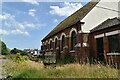
4
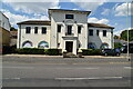
A259 passes Judges Postcards
Between 1903 and 1919 Fred Judge FRPS photographed many of Hastings events and disasters. These included storms, the first tram, visit of the Lord Mayor of London, Hastings Marathon Race and the pier fire of 1917. Many of these images were produced as picture postcards by the British Postcard manufacturer he founded now known as Judges Postcards. See also: http://en.wikipedia.org/wiki/Judges_Postcards
Image: © Stuart Logan
Taken: 27 May 2012
0.05 miles
6
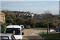
Harley Way, St Leonards, East Sussex
Image: © Oast House Archive
Taken: 25 Oct 2008
0.06 miles
7
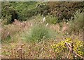
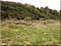
Self-sown pampas grass, Lovat Mead
This picture was taken before this part of Lovat Mead was developed for housing. It appeared to be the floor of an old quarry, or the base of an old cliff (note the bushes at the rear on a very steep slope). Pampas grass (Cortaderia selloana) has been spreading in the wild in Britain since 1925 and is regarded as an undesirable non-native. As well as the pampas grass, there is yellow ragwort, sallow scrub and many other plant species on this classic brownfield site.
Image: © Patrick Roper
Taken: 1 Aug 2004
0.07 miles
8
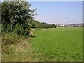
Lovat Mead and West Marina
Taken in 2005 from Harley Shute Road. The flat area of grass and weeds below the cliff scrub has now been developed with blocks of flats. The sea lies in the distance.
Image: © Patrick Roper
Taken: 2 Jul 2004
0.08 miles
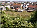
9
Brownfield site at Lovat Mead
This area of grass and scrub below the old cliff-line/quarry (with the bushes) has now been developed for housing.
Image: © Patrick Roper
Taken: 1 Aug 2004
0.08 miles
10
South Saxons, West St Leonards
An open area to the north of the A259 in 2005. The thin, horizontal buff line on the right of the picture is the South Saxons Nature Reserve, a wetland, and the buildings beyond were of Filsham Valley College, now the St. Leonards Academy. The plant on the left between the hawthorn and the brambles is an osier (Salix viminalis), a willow often used in the past for basket making
Image: © Patrick Roper
Taken: 2 Jul 2004
0.09 miles