IMAGES TAKEN NEAR TO
Lullington Gardens, ST. LEONARDS-ON-SEA, TN37 7SH
Introduction
This page details the photographs taken nearby to Lullington Gardens, TN37 7SH by members of the Geograph project.
The Geograph project started in 2005 with the aim of publishing, organising and preserving representative images for every square kilometre of Great Britain, Ireland and the Isle of Man.

There are currently over 7.5m images from over14,400 individuals and you can help contribute to the project by visiting https://www.geograph.org.uk
Image Map (Loading...)


Getting Data...Please wait
Leaflet Map data © OpenStreetMap
Images are licensed for reuse under creativecommons.org/licenses/by-sa/2.0
Notes
- Clicking on the map will re-center to the selected point.
- The higher the marker number, the further away the image location is from the centre of the postcode.
Image Listing (30 Images Found)
Images are licensed for reuse under creativecommons.org/licenses/by-sa/2.0
Image
Details
Distance
2

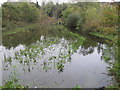
Highlea Pond, St Leonards-on-Sea
South east of Little Ridge Community Primary Academy.
Image: © Patrick Roper
Taken: 24 Feb 2002
0.10 miles
3
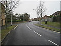
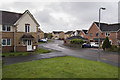
Little Ridge Avenue, St Leonards on Sea
Part of a housing development from about 25 years ago, this road links up with Harrow Lane to the west. Originally the path of Silverhill Avenue, original parts of which still remain.
Image: © Julian P Guffogg
Taken: 15 Nov 2014
0.16 miles
4
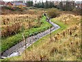
Canalised stream or drain in the Silverhill Park area
Image: © Patrick Roper
Taken: 17 Oct 2002
0.17 miles
5
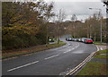
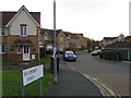
Flooded drain off Little Ridge Avenue
There is a drainage ditch on the right hand side of the picture which has a small outlet. This frequently gets blocked with debris which causes flooding.
Image: © Julian P Guffogg
Taken: 30 Oct 2011
0.18 miles
7
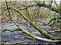
Sallow carr at head of Old Roar valley
This was once a pond to the west of St Anne's Centre on the southern side of The Ridge
Image: © Patrick Roper
Taken: 18 Feb 2002
0.18 miles
9
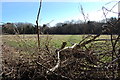
Potential development site
Part of the land which has an application to build 208 houses.
The field is next to the old Holmhurst St Mary convent, which owned a lot of land in this area, and seems to be gradually being sold off.
Image: © Julian P Guffogg
Taken: 22 Feb 2015
0.21 miles
10
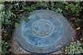
Commemoration Plate, Conquest Hospital
Commemorating the start of work on the new "District General Hospital". The name Conquest was decided by a competition.
Height above ordnance datum is given as 104.26m. The axis of the Hospital is built along the inscribed line several degrees off West-East.
Image: © Julian P Guffogg
Taken: 15 Sep 2012
0.22 miles