IMAGES TAKEN NEAR TO
Beauport Park, BATTLE, TN33 0SQ
Introduction
This page details the photographs taken nearby to Beauport Park, TN33 0SQ by members of the Geograph project.
The Geograph project started in 2005 with the aim of publishing, organising and preserving representative images for every square kilometre of Great Britain, Ireland and the Isle of Man.

There are currently over 7.5m images from over14,400 individuals and you can help contribute to the project by visiting https://www.geograph.org.uk
Image Map
Images are licensed for reuse under creativecommons.org/licenses/by-sa/2.0
Notes
- Clicking on the map will re-center to the selected point.
- The higher the marker number, the further away the image location is from the centre of the postcode.
Image Listing (5 Images Found)
Images are licensed for reuse under creativecommons.org/licenses/by-sa/2.0
Image
Details
Distance
1
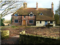
Stonehouse, Beauport Park
Deep in the middle of the woods is this one building. Marked as a farm on the 1805 map but losing that apellation by the 1880 map. The outer buildings include a barn and little else.
Image: © Simon Carey
Taken: 21 Feb 2007
0.02 miles
2
Roman Slag Heap, Beauport Park
In 1869 the rector of Hollington discovered a huge pile of slag in this part of the wood with evidence of Roman Pottery and tiles. What he had discovered was one of the largest Roman iron workings in the entire Empire. At one point there was 100,000 tonnes of slag lying in the vicinity but much of this was used by the 19th century version of the Highway Agency to metal the local roads. In the 1970s a retired classics teacher uncovered an excellently preserved bath house to the south of the heaps believed to have the highest walls still standing. Unfortunately, a lack of money and the remains being on private grounds means the site is not accessible to the public.
Image: © Simon Carey
Taken: 21 Feb 2007
0.16 miles
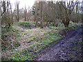
3
Site of Roman Bloomery, Beauport Park
The trees and vegetation conceal the remaining heaps of slag. Beauport Park was chosen as the major site due to its proximity to the coast, there are remains of a road leading from the wood through Crowhurst Park where there was another bloomery then south to an old haven at Bulverhythe. The tiles excavated have found the marks CB which suggests heavy Roman military involvement in the iron works.
Image: © Simon Carey
Taken: 21 Feb 2007
0.17 miles
4
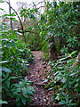
Babylon Wood
Following the footpath through the undergrowth. Babylon Wood is part of Beauport Park.
Image: © Simon Carey
Taken: 21 Feb 2007
0.17 miles
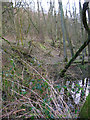
5
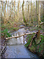
Stream, Keepers Wood
Another tributary of Forge Stream rising in the ridge of Beauport Park.
Image: © Simon Carey
Taken: 21 Feb 2007
0.20 miles