IMAGES TAKEN NEAR TO
The Street, BATTLE, TN33 0QE
Introduction
This page details the photographs taken nearby to The Street, TN33 0QE by members of the Geograph project.
The Geograph project started in 2005 with the aim of publishing, organising and preserving representative images for every square kilometre of Great Britain, Ireland and the Isle of Man.

There are currently over 7.5m images from over14,400 individuals and you can help contribute to the project by visiting https://www.geograph.org.uk
Image Map
Images are licensed for reuse under creativecommons.org/licenses/by-sa/2.0
Notes
- Clicking on the map will re-center to the selected point.
- The higher the marker number, the further away the image location is from the centre of the postcode.
Image Listing (295 Images Found)
Images are licensed for reuse under creativecommons.org/licenses/by-sa/2.0
Image
Details
Distance
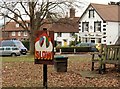
1
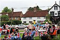
Jubilee tea, Sedlescombe village green
Afternoon tea on 5 June 2022, for residents of Sedlescombe parish to celebrate the platinum jubilee of Queen Elisabeth II. The white weatherboarded house in the background is 'Durud', a 16th C Grade II listed building.
Image: © Patrick Roper
Taken: 5 Jun 2022
0.01 miles
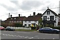
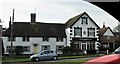
3
Durud & The Clock House, The Street
Durud on the left is Grade II listed http://list.english-heritage.org.uk/resultsingle.aspx?uid=1222149
The Clock House is currently a hair and beauty salon.
Image: © Oast House Archive
Taken: 9 Aug 2014
0.01 miles
5
Village green, Sedlescombe Street
The sign in the foreground is to warn people about the geese that wander round the green every day. The buildings in the distance are The Clock House, currently a beauticians, formerly a café and a shop. In the centre a house called 'Durud', a Grade II listed 16th century timber-framed building, now faced with weather-boarding and to the left 'Sherrald', an 18th century house also listed Grade II. The meaning of the name 'Durud' I have not been able to find, but 'Sherrald' is a fairly widespread first and family name.
Image: © Patrick Roper
Taken: 2 Dec 2016
0.02 miles
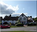
6
Durud and The Clock House, The Street
This picture was taken when the Clock House was a bistro. Earlier it had been a grocer's shop and more recently a hairdressers. See http://www.geograph.org.uk/photo/4112368
Image: © Patrick Roper
Taken: 15 Feb 2007
0.02 miles
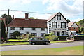
7
Durud/The Clock House, The Street, Sedlescombe
Durud is the weatherboarded house on the left dating from the 16th century. The Clock House to the right was originally an extension of Durud when it served as the village post office prior to the first World War. It is now a hair salon.
Image: © Simon Carey
Taken: 20 Aug 2019
0.02 miles
8
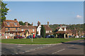
Sedlescombe Village Centre
Village shop and post office on The Green road to the left. The Green itself to the centre and The Street main road to the right.
See more sizes for wider image.
Image: © Oast House Archive
Taken: 6 May 2010
0.02 miles
9
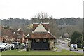
The Green, Sedlescombe
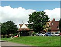
The central building is the Pump House.
Image: © nick macneill
Taken: 30 Jun 2012
0.02 miles
10
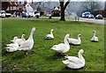
The Green, Sedlescombe Street
View down The Green, over the geese to the pump house just to the left of the tree trunk. The shop and Post Office is on the top left.
Image: © Patrick Roper
Taken: 20 Feb 2017
0.02 miles