IMAGES TAKEN NEAR TO
Willow Mews, ROBERTSBRIDGE, TN32 5NL
Introduction
This page details the photographs taken nearby to Willow Mews, TN32 5NL by members of the Geograph project.
The Geograph project started in 2005 with the aim of publishing, organising and preserving representative images for every square kilometre of Great Britain, Ireland and the Isle of Man.

There are currently over 7.5m images from over14,400 individuals and you can help contribute to the project by visiting https://www.geograph.org.uk
Image Map
Images are licensed for reuse under creativecommons.org/licenses/by-sa/2.0
Notes
- Clicking on the map will re-center to the selected point.
- The higher the marker number, the further away the image location is from the centre of the postcode.
Image Listing (383 Images Found)
Images are licensed for reuse under creativecommons.org/licenses/by-sa/2.0
Image
Details
Distance
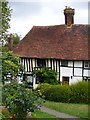
1
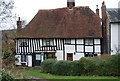
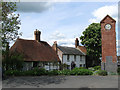
Half timbered cottage, Robertsbridge
Grade II listed.
Image: © N Chadwick
Taken: 24 Dec 2008
0.01 miles
2
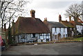
Half timbered cottage, High St
One of several such buildings in Robertsbridge. http://www.geograph.org.uk/photo/1731114 http://www.geograph.org.uk/photo/1731108 The village centre is a conservation area. Grade II listed.
Image: © N Chadwick
Taken: 19 Feb 2009
0.01 miles
3
Footpath sign, off the High St
The other end of this path can be seen at http://www.geograph.org.uk/photo/1730976
Image: © N Chadwick
Taken: 19 Feb 2009
0.01 miles
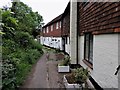
4
Pipers Lane
Pipers Cottage is on the left. The lane originally led down to Darwell Stream but has been built over by the Willow Bank estate. It is now a public footpath.
Image: © Simon Carey
Taken: 3 May 2009
0.01 miles
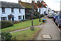
5
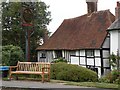
Old timber-framed house and village sign in Robertsbridge
Image: © Robert Edwards
Taken: 2 Sep 2009
0.01 miles
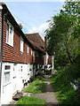
6
Pipers Lane, Robertsbridge
Pipers Lane is a footpath that leads from Robertsbridge High Street to Willow Bank.
Image: © Patrick Roper
Taken: 31 May 2019
0.01 miles
7
Medieval Cottage, Robertsbridge
Idyllic and historic half-timbered house on the main street of the village. The name comes from Abbot Robert de St Martin funding the bridge across the Rother.
http://robertsbridge.east-sussex.co.uk/
Image: © Colin Smith
Taken: 14 Aug 2010
0.02 miles
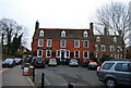
9
Robertsbridge War Memorial
Actually a clock tower as opposed to a straightforward memorial, it was unveiled in 1926 and is opposite the George Inn on High Street. The house to the left is St Catherines which dates back to the 15th century and was named after a nearby well. The area in view is believed to be the original site of the first Cistercian Priory which was founded in 1176 and moved to the east of village in 1210.
Image: © Simon Carey
Taken: 3 May 2009
0.02 miles
10
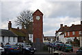
Clock Tower War Memorial, Robertsbridge
An interestingly designed war memorial.
Image: © N Chadwick
Taken: 19 Feb 2009
0.02 miles