IMAGES TAKEN NEAR TO
Lancaster Court, RYE, TN31 7FB
Introduction
This page details the photographs taken nearby to Lancaster Court, TN31 7FB by members of the Geograph project.
The Geograph project started in 2005 with the aim of publishing, organising and preserving representative images for every square kilometre of Great Britain, Ireland and the Isle of Man.

There are currently over 7.5m images from over14,400 individuals and you can help contribute to the project by visiting https://www.geograph.org.uk
Image Map
Images are licensed for reuse under creativecommons.org/licenses/by-sa/2.0
Notes
- Clicking on the map will re-center to the selected point.
- The higher the marker number, the further away the image location is from the centre of the postcode.
Image Listing (229 Images Found)
Images are licensed for reuse under creativecommons.org/licenses/by-sa/2.0
Image
Details
Distance
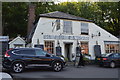
1
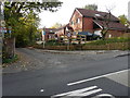
Three new houses, Deadmans Lane
In August 2014 this was a Image Now three houses have been built as described in Rother District Council’s planning application RR/2012/374/P as the “proposed formation of new vehicular access and the erection of 3 dwellings on the land north of Deadmans Lane, Rye, TN31 7HW”.
Image: © John Baker
Taken: 25 Oct 2015
0.01 miles
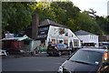
2
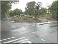
Building site on the corner of Deadmans Lane
Seen from Fishmarket Road (A268), planning permission has been approved, with conditions, by Rother District Council under application number RR/2012/1637/P for the “erection of a three bedroom dwelling”.
Image: © John Baker
Taken: 17 Aug 2014
0.02 miles
3
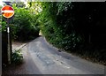
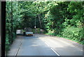
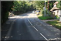
Deadman's Lane, Rye
Linking The Grove to Rye Hill, the A268.
Image: © Simon Carey
Taken: 27 Jun 2019
0.03 miles
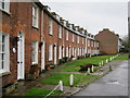
8
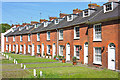
Military Cottages, Rye
A beautiful row of redbrick cottages, built to house soldiers constructing the Royal Military Canal, Military Road, Rye.
Image: © Wayland Smith
Taken: 27 May 2013
0.06 miles
9
37-67 Military Road
Grade II listed https://www.historicengland.org.uk/listing/the-list/list-entry/1251969
Image: © Oast House Archive
Taken: 13 Feb 2018
0.07 miles
10
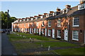
Waterloo Terrace
Grade II listed. http://www.britishlistedbuildings.co.uk/en-434873-waterloo-terrace-rye-east-sussex
Image: © N Chadwick
Taken: 28 May 2016
0.07 miles