IMAGES TAKEN NEAR TO
Bankside, RYE, TN31 7BJ
Introduction
This page details the photographs taken nearby to Bankside, TN31 7BJ by members of the Geograph project.
The Geograph project started in 2005 with the aim of publishing, organising and preserving representative images for every square kilometre of Great Britain, Ireland and the Isle of Man.

There are currently over 7.5m images from over14,400 individuals and you can help contribute to the project by visiting https://www.geograph.org.uk
Image Map (Loading...)


Getting Data...Please wait
Leaflet Map data © OpenStreetMap
Images are licensed for reuse under creativecommons.org/licenses/by-sa/2.0
Notes
- Clicking on the map will re-center to the selected point.
- The higher the marker number, the further away the image location is from the centre of the postcode.
Image Listing (134 Images Found)
Images are licensed for reuse under creativecommons.org/licenses/by-sa/2.0
Image
Details
Distance
1
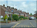
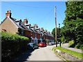
Houses on Pottingfield Road, Rye
The bus stop is called Denton Close.
Image: © Robin Webster
Taken: 29 May 2014
0.08 miles
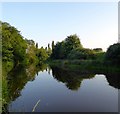
2
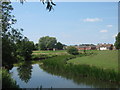
River Tillingham towards Rye
As seen from a riverside path.
Image: © David Anstiss
Taken: 3 Jul 2011
0.09 miles
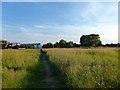
3
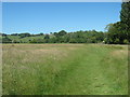
High Weald Landscape Trail to Rolvendene Farm
The long distance path leads from Ferry Road, Rye beside a flood plain near the River Tillingham towards the farm, before heading towards Peasmarsh.
Image: © David Anstiss
Taken: 26 Jun 2011
0.10 miles
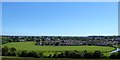
4
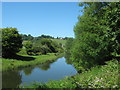
River Tillingham near Rolvendene Farm
As seen from the High Weald Landscape Trail (long distance path) between Rye and Peasmarsh.
Rolvendene Farm is in the background, above it on Leasam Hill, is Leasam Farm.
Image: © David Anstiss
Taken: 26 Jun 2011
0.10 miles
5
River Tillingham
Viewed in the late evening sun.
Image: © Simon Carey
Taken: 27 Jun 2019
0.10 miles
6
Mill Salts
The name of the field according to Rye's 1840 tithe map that is bounded by the River Tillingham to the north and west.
Image: © Simon Carey
Taken: 22 Jun 2019
0.10 miles
7
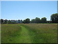
High Weald Landscape Trail to Rye
The long distance path leads from Rolvendene Farm, beside a river plain near the River Tillingham towards Ferry Road.
Image: © David Anstiss
Taken: 26 Jun 2011
0.11 miles
8
Ram Marsh (2)
The name of the field according to Rye's 1840 tithe map viewed from Leasam Hill and showing the full extend of the current field which is bounded to the north, east and west by the River Tillingham. Part of the original field has been lost to housing.
Image: © Simon Carey
Taken: 22 Jun 2019
0.11 miles
9
Ram Marsh (1)
The name of the field according to Rye's 1840 tithe map that is located to the south and west of the River Tillingham.
Image: © Simon Carey
Taken: 22 Jun 2019
0.12 miles
10
20-40, Tillingham Avenue, Rye
Built in the first decade of the 20th century and originally known as Tillingham Villas. A number of terraced properties were built in that period on the western side of the town and given individual names but have now been co-opted into the numbering scheme of the roads they are located in.
Image: © Simon Carey
Taken: 22 Jun 2019
0.12 miles