IMAGES TAKEN NEAR TO
Udimore Road, RYE, TN31 6AP
Introduction
This page details the photographs taken nearby to Udimore Road, TN31 6AP by members of the Geograph project.
The Geograph project started in 2005 with the aim of publishing, organising and preserving representative images for every square kilometre of Great Britain, Ireland and the Isle of Man.

There are currently over 7.5m images from over14,400 individuals and you can help contribute to the project by visiting https://www.geograph.org.uk
Image Map
Images are licensed for reuse under creativecommons.org/licenses/by-sa/2.0
Notes
- Clicking on the map will re-center to the selected point.
- The higher the marker number, the further away the image location is from the centre of the postcode.
Image Listing (16 Images Found)
Images are licensed for reuse under creativecommons.org/licenses/by-sa/2.0
Image
Details
Distance
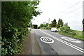
2
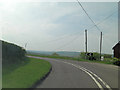
B2089 northwest of Cock Marling
For aficinados of utility service wires and poles this must be a prime site.
Image: © Stuart Logan
Taken: 19 May 2013
0.03 miles
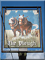
6
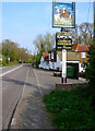
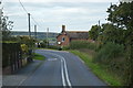
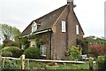
The Plough, Cock Marling
Small hamlet on the B2089 Rye-Broad Oak road consisting of this inn and a few houses. Cock Marling lies on the ridge that separates the Tillingham and Brede river valleys.
Image: © Simon Carey
Taken: 13 Apr 2007
0.13 miles
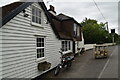
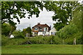
10
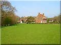
Cock Marling
Taken from the footpath to Float Farm.
Image: © Simon Carey
Taken: 13 Apr 2007
0.19 miles