IMAGES TAKEN NEAR TO
Samphire Way, TN28 8LX
Introduction
This page details the photographs taken nearby to Samphire Way, TN28 8LX by members of the Geograph project.
The Geograph project started in 2005 with the aim of publishing, organising and preserving representative images for every square kilometre of Great Britain, Ireland and the Isle of Man.

There are currently over 7.5m images from over14,400 individuals and you can help contribute to the project by visiting https://www.geograph.org.uk
Image Map
Images are licensed for reuse under creativecommons.org/licenses/by-sa/2.0
Notes
- Clicking on the map will re-center to the selected point.
- The higher the marker number, the further away the image location is from the centre of the postcode.
Image Listing (180 Images Found)
Images are licensed for reuse under creativecommons.org/licenses/by-sa/2.0
Image
Details
Distance
1
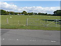
Looking north-northeast from Ashford Road
Over a field filled with grazing sheep.
Image: © John Baker
Taken: 16 Aug 2015
0.01 miles
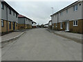
2
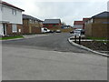
Samphire Way
The close will form part of Mulberry Place.
Image: © John Baker
Taken: 29 Jan 2023
0.01 miles
3
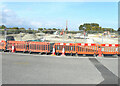
Development land
The site has been acquired by Pentland Homes for a stunning collection of 2, 3 and 4 bed homes; the development will form part of Mulberry Place.
This view of the Image was photographed in May 2021.
Planning permission has been approved, with conditions, by Folkestone and Hythe District Council under application number Y18/1404/FH for an “outline planning application for the erection of up to 117 dwellings with public open space, landscaping and sustainable drainage system and vehicular access point from Ashford Road. All matters reserved except for means of access”. The development includes the site of Image
Image: © John Baker
Taken: 12 Sep 2021
0.02 miles
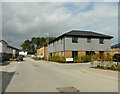
4
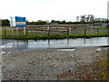
Development land
Viewed from Ashford Road, the noticeboard indicates the site has been acquired by Pentland Homes for a stunning collection of 2, 3 and 4 bed homes and that the development will form part of Mulberry Place. This view of Image is an example of the houses already under construction.
Planning permission has been approved, with conditions, by Folkestone and Hythe District Council under application number Y18/1404/FH for an “outline planning application for the erection of up to 117 dwellings with public open space, landscaping and sustainable drainage system and vehicular access point from Ashford Road. All matters reserved except for means of access”. The development includes the site of Image
The puddles and wet road surface were caused by coastal showers.
Image: © John Baker
Taken: 2 May 2021
0.02 miles
5
Burley Way
This section of the road is further from its junction with Ashford Road, than this view of Image The road will form part of Mulberry Place.
Image: © John Baker
Taken: 29 Jan 2023
0.02 miles
6

Burley Way
A similar view of Image was taken in January 2023. The road will form part of Mulberry Place.
Image: © John Baker
Taken: 19 Feb 2023
0.02 miles
7

Burley Road
A similar view of Image was taken in February 2023; the road will form part of Mulberry Place.
Image: © John Baker
Taken: 4 Jun 2023
0.02 miles
8
Burley Road
A similar view of Image was taken in June 2023; the road will form part of Mulberry Place.
Image: © John Baker
Taken: 2 Jul 2023
0.03 miles
9

Peter J Goddard, Cockreed Lane
This is a business that specialises in landscaping and gardening services http://new-romney.cylex-uk.co.uk/company/peter-j-goddard-16353071.html Formerly it was a garden centre, which I used to patronise years ago.
Image: © John Baker
Taken: 16 Aug 2015
0.03 miles
10
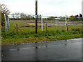
Development land
Viewed from Ashford Road, this view of the Image shows it from another location.
Planning permission has been approved, with conditions, by Folkestone and Hythe District Council under application number Y18/1404/FH for an “outline planning application for the erection of up to 117 dwellings with public open space, landscaping and sustainable drainage system and vehicular access point from Ashford Road. All matters reserved except for means of access”. The development includes the site of Image
The puddles and wet road surface were caused by coastal showers.
Image: © John Baker
Taken: 2 May 2021
0.03 miles