IMAGES TAKEN NEAR TO
Ashford Road, NEW ROMNEY, TN28 8HP
Introduction
This page details the photographs taken nearby to Ashford Road, TN28 8HP by members of the Geograph project.
The Geograph project started in 2005 with the aim of publishing, organising and preserving representative images for every square kilometre of Great Britain, Ireland and the Isle of Man.

There are currently over 7.5m images from over14,400 individuals and you can help contribute to the project by visiting https://www.geograph.org.uk
Image Map
Images are licensed for reuse under creativecommons.org/licenses/by-sa/2.0
Notes
- Clicking on the map will re-center to the selected point.
- The higher the marker number, the further away the image location is from the centre of the postcode.
Image Listing (388 Images Found)
Images are licensed for reuse under creativecommons.org/licenses/by-sa/2.0
Image
Details
Distance

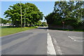
4
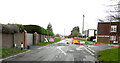
Ashford Road
The road was closed between Rolfe Lane and Cockreed Lane and motorists had to make diversions using these roads. However, it was possible to drive to view the Image This was due to some of the barriers having been blown over by the wind and also that there were no contractors working on the site because it was a Sunday.
Image: © John Baker
Taken: 6 Feb 2022
0.03 miles

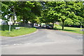
10
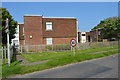
Burley Way
The site has been acquired by Pentland Homes for a stunning collection of 2, 3 and 4 bed homes; the development will form part of Mulberry Place.
This view of Image was photographed in September 2021.
Planning permission has been approved, with conditions, by Folkestone and Hythe District Council under application number Y18/1404/FH for an “outline planning application for the erection of up to 117 dwellings with public open space, landscaping and sustainable drainage system and vehicular access point from Ashford Road. All matters reserved except for means of access”.
Image: © John Baker
Taken: 6 Feb 2022
0.07 miles