IMAGES TAKEN NEAR TO
Church Lane, NEW ROMNEY, TN28 8ER
Introduction
This page details the photographs taken nearby to Church Lane, TN28 8ER by members of the Geograph project.
The Geograph project started in 2005 with the aim of publishing, organising and preserving representative images for every square kilometre of Great Britain, Ireland and the Isle of Man.

There are currently over 7.5m images from over14,400 individuals and you can help contribute to the project by visiting https://www.geograph.org.uk
Image Map
Images are licensed for reuse under creativecommons.org/licenses/by-sa/2.0
Notes
- Clicking on the map will re-center to the selected point.
- The higher the marker number, the further away the image location is from the centre of the postcode.
Image Listing (363 Images Found)
Images are licensed for reuse under creativecommons.org/licenses/by-sa/2.0
Image
Details
Distance
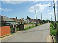
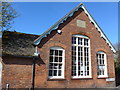
2
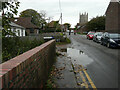
Church Lane
The brick wall was part of a bridge under which the New Romney Main Sewer flows. The large puddle indicated that rain had fallen recently. Two cyclists were making their way toward the camera with the tower of St Nicholas church behind them.
Image: © John Baker
Taken: 16 Oct 2022
0.02 miles
3
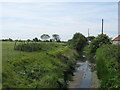
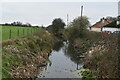
New Romney Main Sewer
This field drain leads through New Romney towards the Dengemarsh Sewer (another large field drain).
As seen from Church Lane.
Image: © David Anstiss
Taken: 14 Jun 2011
0.03 miles
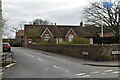
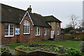
10
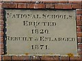
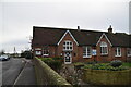
Plaque on the old school, New Romney (1)
Image: © Basher Eyre
Taken: 9 Apr 2014
0.04 miles